

The final days of October are upon us and with that, the close of Archaeology Month in Pennsylvania. As part of our Archaeology Month programming we visited Cabela’s in Hamburg, Pennsylvania on Sunday, October 21st. The public loves learning about archaeology and Native American prehistory. Our replica of a Native American dugout canoe is always an attention getter, and once again crowds flocked to sit in it for a Kodak moment. If you haven’t had a chance to visit an archaeological site somewhere across the commonwealth this month, don’t despair- our blog by county format has returned and you can catch up on a new county right now!
 |
| Kodak moment in the dugout at Cabela's |
We have returned to the topic of Pennsylvania’s archaeological tour of the counties which features a new county each week. This week we travel to Fulton County which encompasses an area of 438 square miles located in the south central region of our Commonwealth bordering the state of Maryland. The county is named after Robert Fulton (1765-1816) an American engineer and inventor who was born near here. Perhaps best known for his development of the steamboat, he also designed the Nautilus, a working submarine for Napoleon Bonaparte. Robert Fulton was also an accomplished portrait and landscape artist and over the course of his life he was associated with such men as Ben Franklin, Benjamin West and Robert Livingston.
 |
| Robert Fulton's 3-stacked steamboat, on the Hudson River (Library of Congress) |
Regarding the natural and archaeological facts of Fulton County, its physiography, hydrology and geology can be generally summarized as follows: Situated within the Appalachian Mountain Section of the Ridge and Valley Province the area is principally characterized by mountains and valleys that geologists have termed the Appalachian orogeny (325-260 million years ago). This event, in which the continents collided to form the super continent of Pangaea created the rugged Appalachian mountain range which extends from Maine to Alabama. Much of Fulton County is drained by the Tonoloway Creek, Licking Creek and Cove Creek sub-drainages. These and other smaller unnamed waterways to the south, west, north and east belong to the three larger watersheds to the immediate region – the Susquehanna, the Juniata and the Potomac. From an archaeological perspective Fulton County’s regional prehistory is defined by the context of these watersheds and the territory which they encompass.
 |
| Image of Cowans Gap State Park (www.parkvisitor.com) |
Reviewing the data base of recorded archaeological sites in the Pennsylvania Archaeological Site Survey (P.A.S.S.) file for Fulton County, one finds that there is a rather diverse list of sites with associated chipped stone artifacts that range from the Late Paleo-Indian through the end of the Woodland period.
The archaeological survey completed under the Pennsylvania Regional Archaeology Program (Herbstritt 1982) revealed the following information. A Hardaway side notched point made from weathered rhyolite is reported from a site in the Big Cove Tannery drainage and at least 39 diagnostic points belonging to the Early Archaic period have been recovered from five sites. Recognized diagnostics include Kirk, MacCorkle, St. Albans,Lecroy and Kanawha and are generally made of rhyolite and chert. Moving on to the Middle Archaic period, Stanly and Otter Creek were the most frequently encountered types. Again, like the Middle Archaic points, these were fashioned from South Mountain rhyolite and local cherts. Late Archaic styles include stemmed and notched types of the Vernon phase and the tentatively identified Bare Island type. Brewerton types are generally common, as well. Along with the broad spears of the Transitional-Archaic these are of South Mountain rhyolite.

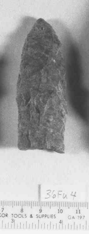
Kirk Point -Early Archaic (36Fu18)

Bifurcate Point -Early Archaic (36FU18)
Bifurcate Point -Early Archaic (36FU18)

Stanly Point -Middle Archaic (36FU12)
Perkiomen Broadspear-Transitional Period(36Fu12)
The Woodland period in Fulton County is represented by Early Woodland Orient-like fishtails, Rossville, Clagett and Hellgrammite points; ceramics are absent. The Middle Woodland Selby Bay or Fox Creek knife is prolific in the Fulton County area especially in the Big Cove Tannery and Licking Creek sub-drainages. Evidence of the Kipp Island phase is reported from four sites in Fulton County. Although few in number the fact that they have been found in such a remote region of the Middle Atlantic, is noteworthy. As for the Early Woodland period, ceramics have not been reported. There are four sites representative of the Late Woodland period and they are all located in the Licking Creek/Big Cove Tannery drainage. The sites are recognized by the presence of triangular points, however, only one of these sites have yielded limestone tempered ceramics of the Page Cordmarked type, a regional ceramic type indicative of the earlier end of the Late Woodland period.
 |
| Rossville-Early Woodland(2,100-2,700 years ago) |
 |
| ,Selby Bay-Middle Woodland (1,100-2,100 years ago) |
 |
| Jacks Reef-Middle Woodland |
 |
| Madison Point-Late Woodland(450-1,100 years ago) |
Few archaeological surveys have been done under Section 106 of the National Historic Preservation Act. However, a Phase 1 level archaeological survey ER#98-8056-057-B was completed on a proposed wetlands replacement location in Licking Creek Township south of Harrisonville, Fulton County (Raber and Heberling 1998). There, two prehistoric archaeological sites were identified and their locations are adjacent to Licking Creek. Shovel and auger testing completed during project recovered an isolated Dalton-Hardaway point made of jasper at one location and a hammer stone and nine pieces of chert at another nearby location. District 9-0 Pennsylvania Department of Transportation elected to avoid impacting the site with the creation of a wetlands area thereby avoiding any subsequent archaeological investigations in the area of potential affect.
Few important Historic period sites are currently identified in Fulton County, Pennsylvania. The French and Indian War Period site of Fort Lyttleton, however, is considered among the sites that would justify archaeological testing to locate its actual location. Fort Lyttleton was begun by George Croghan in 1755 and garrisoned by provincials until the Forbes campaign in 1758. There are two nearby contemporary fort sites, Fort Loudoun in Franklin County and the recently discovered Fort Shirley in Huntingdon County. Information detailing the excavations at the latter site will be presented during the November 3rd Workshops in Archaeology in Harrisburg, so plan to attend!
We hope you have enjoyed this brief introduction to Fulton County and its archaeological resources. These resources are Pennsylvania’s heritage and for all of us it is our window into the past. Please help us preserve these important resources by reporting and recording your archaeological finds while we all Preserve our Past for the Future.
References
Herbstritt, James T.
1982 Prehistoric Archaeological Site Survey in Pennsylvania Region II with Emphasis on Fulton County Cultural Resources. Final Report submitted to the Pennsylvania Historical and Museum Commission.
Raber, Paul A. and Scott D. Heberling
1998 Phase I Archaeological Survey Proposed Wetland Replacement Area, Licking Creek Township, Fulton County, Pennsylvania. Report submitted by Heberling Associates, Inc., to District 9-0 Pennsylvania Department of Transportation and the Federal Highway Administration.
For more information, visit PAarchaeology.state.pa.us or the Hall of Anthropology and Archaeology at The State Museum of Pennsylvania .
No comments:
Post a Comment