Sunday, May 29, 2022

From Sayre to Sunbury: The Agnes Flood and its Impact on Cultural Resources

The 1972 Agnes flood affected the lives of thousands of people in the Upper Susquehanna Valley. People perished, personal, commercial, and municipal properties destroyed or otherwise altering the local economies resulted in billions of dollars in lost revenue and cost reconstruction. As well, the removal and redeposition of soils from Agnes’ wrath was destructive to archaeological and historical resources from Sayre to Sunbury and beyond.

Figure 1. Upper Susquehanna Valley affected by Agnes


In early July, only weeks after the 1972 flood, a Native American Indian site was discovered by amateur archaeologists on the Sheshequin Flats located down river from the Sayre/Athens area. The Sheshequin location forms part of a series of sites previously identified in the early 20th century by river expeditions.  Historic documents identify the Sheshequin Path which ran from the Lycoming Valley to Towanda Creek as an important foot path developed by the tribes of this region and later utilized by settlers. Historic accounts of the Moravian Mission (1769-1772) located at present-day Ulster, Bradford County recorded evacuation of the village for a few days due to flooding in 1771. The Moravians left the village in 1772 and led a group of followers west to the Allegheny River. Among them were the two sons and a nephew of Teedyuscung, an important Delaware leader and negotiator.  The rich cultural heritage of this area was exposed as the result of Agnes’s destruction.

Over a three-week period, the archaeologists uncovered pottery and clay pipe fragments, stone arrow points and other prehistoric objects of the Late Woodland period (AD. 900 – AD. 1500). The artifacts lay on the surface of the flood scoured area adjacent to the active channel of the Susquehanna River. Concurrently, archaeological remains were also found by local artifact collectors on Queen Esther’s Flats and on the broad floodplain formed by Tioga Point at the juncture of the Chemung River and North Branch Susquehanna River. Diagnostic artifacts from these other sources were representative of the Late Archaic/Transitional (4000 BCE – 2000 BCE) through the Late Woodland AD. 900 – AD. 1500) periods.

Figure 2. Susquehannock pot fragment (photo: Smithsonian Institution)


Figure 3. Artifacts recovered from the Sheshequin, Queen Esther's Flats, and Tioga Point.
Image from the collections of The State Museum of Pennsylvania

The broad floodplain from Pittston to Nanticoke, Pennsylvania geographically known as the Wyoming Valley, suffered massive inundation and destruction by the flood waters of Agnes. The damage was so severe at the river town of Forty Fort, Luzerne County, that the earthen dike gave way, destroying a cemetery containing many graves. The stone monument erected in memory of the deceased reads:

“On the afternoon of Friday June 23, 1972, the Susquehanna River swollen by the flood waters of unprecedented height broke through the dike at a point 120 yards south of this site. The swirling water gouged a four-acre chasm out of the heart of the cemetery displacing approximately 2500 burials. This park is dedicated by the Forty Fort Cemetery Association to the memory of those whose gravesites vanished in that singular catastrophe”

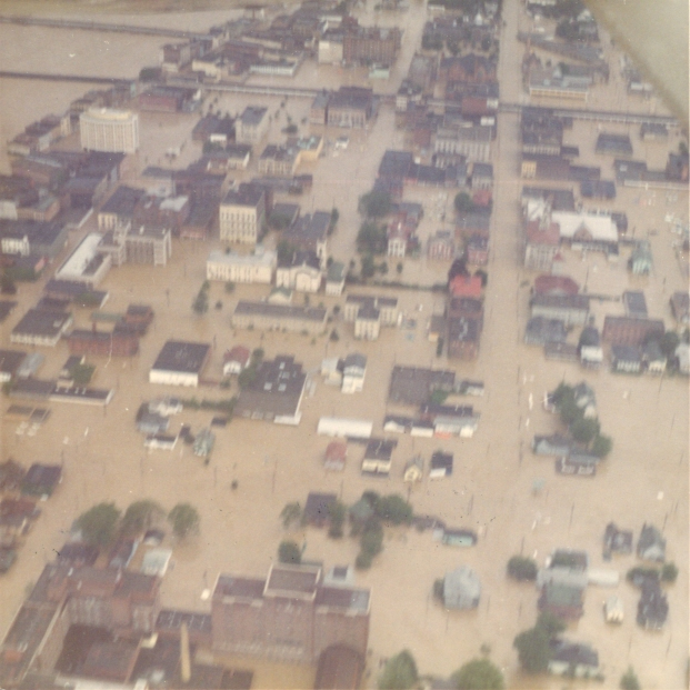
Wilkes Barre was hit hard by the Agnes flood where the river rose above the 42-foot mark - the impact was devastating. The Archaeology Laboratory and the artifact storage areas at Kings College were completely submerged. Water damage to the facility was significant with the irreparable loss of artifacts and field/lab records from Kings College’s early archaeological investigations at the Kennedy (36BR0043) and Friedenshutten sites in Bradford County. Friedenshutten was founded in 1752 as a Delaware settlement and by 1763, David Zeisberger a Moravian missionary had constructed a church within the village. The site was home to the Delaware and Shawnee tribes until it was abandoned in 1772 during removal of the tribes to Ohio.  

Several other archaeological sites previously spared by floods located near the town of Plains were wiped out leaving no traces of their presence.  After the flood the artifacts housed at the Kings College repository were transferred to Bradford County where they are now under curation at the Wyalusing Valley Museum Association.
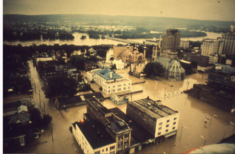
Figure 4. Wilkes/King's College during the Agnes flood of 1972 (photo: Wilkes.edu)


Figure 5. Before and after images of the King's College archaeology laboratory due to flooding caused by Agnes.
Image credit: D. Leonard Corgan Library

The archaeological sites impacted by the Agnes Flood south of the Wyoming Valley on the floodplain of the North Branch are not well documented beyond the information derived from first - hand accounts of surface collectors.  Numerous archaeological sites near Northumberland, Pennsylvania were also inundated. The Central Builders site(36NB0117) located a short distance south from Danville, Pennsylvania was one of the sites frequently hunted by artifact collectors. There, stone projectile points affiliated with the Early Archaic (9000 BCE) through Late Woodland (AD. 900 – AD. 1500) period were recovered. Years after the Agnes flood ripped through the valley, investigations conducted by the Pennsylvania Historical and Museum Commission uncovered a deeply stratified multicomponent archaeological deposit at the Central Builders site demonstrating the importance of such sites containing very old Native American occupations.

Figure 6. Riverbank cut at Central Builder's site showing stratigraphic deposits from flooding.


Figure 7. Early Archaic Kirk projectile point found in situ at the Central Builder's site(36NB0117).
Images from the collections of The State Museum of Pennsylvania


Figure 8. Kirk point from image above after cleaning and cataloging


Downstream from the Central Builders site, flood waters scoured and reshaped the river islands between Berwick and Danville. Significant damage caused by flooding at the north end of Packers Island exposed the remains of a Late Woodland site where surface hunters found the remains of pit features, sherds of pottery and stone projectile points.


Figure 9. Ceramic and lithic artifacts from Packer's Island(36NB0075)
Image from the collections of The State Museum of Pennsylvania

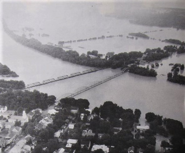
Flooding at the confluence of the Susquehanna’s West Branch and North branches created a pooling effect raising the flood stage to a record of 35.80 feet, a record for the Susquehanna River Valley.

This has been the third installment of TWIPA’s blog on the Agnes flood and archaeological sites in Pennsylvania. Please join us next time for more on Agnes and its impact on archaeological sites and the discovery of sites from flood management projects implemented after Agnes.  The series will continue through the month of June and the anniversary of this event. A Learn at Lunchtime with Curator, Janet Johnson will discuss the impact of Agnes on the cultural resources of the Commonwealth and highlight archaeological sites explored in this blog series. 


References

Delaney, Leslie L., Jr.

1973    Search for Friedenshutten 1772-1972, A Bicentennial Archaeological and Historical Project Report for Northeastern Pennsylvania, Cro Woods Publishing, Wyoming, PA

 Donehoo, George P.

1928         A History of the Indian Villages and Place Names in Pennsylvania. Harrisburg.

 n.d.   The Historical Marker Database, HMdb.org. Forty Fort Cemetery Lost Graves Memorial.  https://www.hmdb.org/m.asp?m=105296     

n.d.  Native History of the Wyoming Valley, Christianity and Colonization, Friedenshutten Mission

https://digitalprojects.scranton.edu

 Wallace, Paul A.W.

1965       Indian Paths of Pennsylvania. Pennsylvania Historical and Museum Commission. Harrisburg.


For more information, visit PAarchaeology.state.pa.us or the Hall of Anthropology and Archaeology at The State Museum of Pennsylvania .

Monday, May 16, 2022

Agnes’s Impact on the Northern Tier of Pennsylvania

Recent weather conditions in the South-Central Region of Pennsylvania were reminiscent of the seemingly endless rain of Tropical Storm Agnes, but Agnes was a steady deluge that swelled streams and rivers over their banks. The difference is obvious in that we experienced approximately 4 inches of rain this past weekend as opposed to 12, 14 and upwards of 19 inches from Agnes.  As we continue our series of blogs focused on the impact on cultural resources due to flooding from the storm, our area of focus this week is North Central PA and the Southern tier of New York around Chemung and Elmira, NY. 

Major River Basins, Tioga River Valley circled


Tioga County is in the Glaciated High Plateau, Glaciated Low Plateau and Deep Valleys Sections of the Appalachian Plateau Province. These physiographic landforms are characterized by eroded hills and generally narrow, steep sided valleys.  The major streams are the Cowanesque and Tioga Rivers that form the major waterways of the Chemung and the Susquehanna’s North Branch drainage. Pennsylvanian, Mississippian, and Devonian rocks constitute the geological makeup of Tioga County and originally these rocks were a part of the vast sea sediments that formed some 290-405 million years ago. 

The Cowanesque River is a major west-east drainage in northern Tioga County. It is a tributary of the Tioga River, which flows north to join the Chemung in New York state. The Chemung then curves to flow south to join the North Branch of the Susquehanna River. The Cowanesque River basin lies in both Pennsylvania and New York, draining an area of 772 km^ (298 mi^). The headwaters of the Cowanesque River are in the Allegheny High Plateau section located west of Tioga County, in north central Potter County. From there, the river flows approximately 61 km (38 mi) east to join the north-flowing Tioga River at Lawrenceville.

This environment creates an ideal setting for flood waters to inundate the small streams and tributaries that feed these larger waterways, leading to major flooding in the region during increased precipitation. Spring ice jams, snow thaws and heavy thunderstorms had contributed to previous catastrophic storms in 1889, 1935 and 1946 to name a few. The Army Corp of Engineers authorized the construction of a flood control project to in July 1958 to alleviate flooding. However, construction did not begin until after Agnes struck her heavy blow.  

 Location of Project Area (Goodwin 1990)


In preparation for construction, several surveys were initiated by the National Park Service and the Army Corp. to review the potential impact on cultural resources.  The project involved the construction of two dams, the Tioga-Hammond Lake, and the Cowanesque Dam- see map above. Archaeological surveys by Dr. Jacob Gruber of Temple University recorded new sites and revisited sites previously surveyed by John Witthoft of the Pennsylvania Historical Commission (now the PHMC). Impact areas were identified and plans for recovery or preservation of these resources were developed. The small village of Nelson, including the Presbyterian Church and cemetery, was moved to higher ground above the Cowanesque Flood plain.  Prior to the move, local residents were surveyed for their opinion on relocating and their oral histories documented. Today, the village is perched on a hillside overlooking the dam. 

Beecher's Island Presbyterian Church, Nelson. PA-SHPO, PHMC, PA-SHARE


Archaeological sites recorded through these efforts were scant. In fact, Gruber reported that the flooding in 1946 had obliterated any evidence of precontact human occupation in the Tioga River Valley or in the adjacent Crooked Creek Valley. “I must conclude, therefore, that these areas were not subject to prehistoric settlement.”  Although John Witthoft had recorded a site (36TI0001) at the confluence of the Tioga River and Crooked Cree. Local collectors were also aware of the site and shared their collections with Dr. Gruber. Gruber noted the presence of soapstone (steatite), bannerstone, and many points (projectile points), but did not consider this as significant information.  

Onondaga chert points (36TI0001). The State Museum of Pennsylvania


Late Woodland Pottery (36TI0001). The State Museum of Pennsylvania


Dr. Gruber’s survey identified potential sites in the Cowanesque Valley, the Antonio site(36TI0030) received preliminary salvage archaeology during the summers of 1966 and 1967 by Temple students as reported by Daniel Crozier. The site was assigned to the Early Woodland to Late Woodland culture periods based on ceramics, stone tools and projectile points recovered. Storage pits were identified, a hearth feature and an undetermined activity area. Crozier recommended the Army Corp. purchase the site in 1973 to allow for extensive archaeology, unfortunately no additional archaeology was undertaken at this site.  

Stone Tools - net sinker, bipitted processing stones(36TI0001). The State Museum of Pennsylvania


The construction of the dams and subsequent expansion of the capacity of the Cowanesque Dam led to the discovery of additional sites and an opportunity to expand our knowledge of the region.  Of the six sites recorded, three of the buried floodplain sites (36Ti33, 36Ti34, and 36Ti37), appeared capable of documenting the transition from the hunting-gathering late Middle Woodland to the horticultural early Late Woodland and were identified for further investigation. 
 
Archaeological reports for north central Pennsylvania report precontact traditions as evolutionary and typologically comparable to the Archaic and Woodland cultural periods. The periods represented by the components at these sites, which date ca. A.D. 160 (second prehistoric component at 36Ti34) to ca. A.D. 1200 (36Ti37), span a time of important cultural change in eastern North America corresponding to the appearance of maize horticulture in the Northeast. The shift from a somewhat mobile, hunting-gathering oriented late Middle Woodland peoples to maize using, more sedentary early Late Woodland peoples is a major culture change and an interesting research topic for archaeologists. Data from these floodplain sites were thought to be relevant to questions about the development of horticulture as an activity associated with spring fishing camps, thus suggesting an explanation for why maize horticulture spread so quickly among otherwise non-horticultural, forest dwelling peoples. 

Archaeologists recovered ceramics, tree-nut remains and a fragment of a maize cob. Nuts identified included hickory, oak acorn, and hazelnut.  Seeds identified were chenopodium, seed of tick-clover {Desmodium spp.), a wild legume (Fabaceae) cotyledon fragment, a possible ash samara kernel, a hawthorn {Crataegus spp.) nutlet fragment. Among these, it is possible that only the hawthorn nutlet represents a food remain. Unfortunately, poor preservation of bone limited the recovery of dietary remains to those recovered through floatation. Calcined bone fragments were too small to identify. Plowing activities had disturbed features and mixed the artifacts associated with them across the landscape (Goodwin 1990). 

Excavations at 36Ti34 also exposed the remains of a burned log cabin, dated between A.D. 1790 to 1830. The historic component was represented by the charred, virtually intact floor of the cabin, several pit and trough features, and by a large and varied array of historic artifacts. 

The impact of Tropical Storm Agnes on communities in the Cowanesque and Tioga River Valley was catastrophic, but the damage there paled in comparison to the havoc incurred when the waters of the Tioga River merged with the Chemung near Corning, New York.  We will continue our series on Agnes in a few weeks when we trace the impact of the Chemung River as it flows back into Pennsylvania in Bradford County. 

The Army Corp of Engineers estimates that these flood control projects, the Cowanesque and Tioga-Hammond Lakes, the potential for downstream flooding and related damages will be significantly reduced.  It is estimated that, the two projects would have prevented an estimated $360 million in damage during Tropical Storm Agnes. Of this total, Cowanesque Lake alone would have prevented about $142.8 million in damage along the Cowanesque, Tioga, Chemung, and Susquehanna Rivers between Lawrenceville and Sunbury (all values given in 1972 dollars and for 1972 conditions).

The impact of flooding and soil erosion continues to harm archaeological sites and identifying their location and providing protection to these cultural resources is important in preserving our past for future generations. Please support these efforts and record known archaeological sites in the Pennsylvania Historical and Museum Commissions reporting system, PA-SHARE.  

References

Crozier, Daniel A.
1972   Preliminary Archaeological Salvage Operations in a Portion of the Cowanesque Dam Flood Control Project: The Antonio Site 36Ti30. Report submitted to U.S. Department of Interior, National Park Service, Northeast Region.

Gruber, J.W.
1965     An Archaeological Survey of Some Dam Areas in Berks, Carbon, Tioga, and Centre Counties, Pennsylvania. Report submitted to the U.S. Department of interior, National Park Service, Northeast Region.

Gruber, J.W.
1966     An Archaeological Survey at Certain Reservoir Areas in Pennsylvania. Report  submitted to the U.S. Department of Interior, National Park Service, Northeast Region.

Hay, C.A., C. Stevenson
1984    Phase III Archeological Data Recovery From 36Ti33, 36Ti34, And 36Ti37,   Cowanesque Lake Reformulation Project, Tioga County, Pennsylvania.
Baltimore: U.S. Army Corps of Engineers, Baltimore District.

Neumann, Thomas W. , Neal H. Lopinot, Leslie D. McFaden, R. Christopher Goodwin, and Jennifer Cohen
1990    PHASE III Archeological Data Recovery From 36Ti33, 36Ti34, And 36Ti37,    Cowanesque Lake Reformulation Project, Tioga County, Pennsylvania. 
Baltimore: U.S. Army Corps of Engineers, Baltimore District.


For more information, visit PAarchaeology.state.pa.us or the Hall of Anthropology and Archaeology at The State Museum of Pennsylvania .


Monday, May 2, 2022

Hurricane - Tropical Storm - The Destructive Path of Agnes


Fifty years ago, during the summer of 1972 a natural disaster, struck the eastern United States that would leave a lasting impact on communities, disaster reporting systems, and flood control projects from Florida to Maine.  This week we are launching a series of blogs on the path of destruction from Hurricane Agnes as it was known when it made landfall in Florida on June 19th and its downgrade to a Tropical Depression as it moved slowly up the eastern seaboard.  The storm intensified off the coast of Virginia and was close to hurricane magnitude when it moved north, dumping rainfall between 10-19 inches across Pennsylvania, Maryland, and New York from June 21st through June 23rd.  The highest recorded rainfall occurred in Western Schuylkill County, Pennsylvania (19 in.).  Agnes released a deluge which quickly inundated streams and rivers, bringing with them flooding beyond imagination.  The National Weather Service reported a record $3.5 billion of property damage and 118 people died in Agnes’s path.  

This image depicts the storm track and rainfall for Agnes. Source: Hydrometeorological Prediction Center/ NOAA


Pennsylvania’s rivers and streams were already swollen from heavy rains the previous week and the saturated ground couldn’t absorb the impact of this constant rainfall. The Susquehanna River Basin and Schuylkill River Basin, located within the Delaware River Basin on this map, were significantly impacted by flooding.  In the Susquehanna River Basin, the Tioga River flows north into New York where it enters the Chemung River, the Chemung flows southeast back into Pennsylvania through Bradford County where it joins the Susquehanna River.  This entire region was heavily impacted by the flooding which required assistance from the National Guard to evacuate homes and maintain security. 


Map of Pennsylvania’s Major River Basins, Department of Conservation and Natural Resources. Note the red ovals indicating the Tioga, Susquehanna, and Schuylkill Rivers headwaters. 


During the days that followed, scenes of destruction left Pennsylvania residents in disbelief. Nature had shown its force as tons of earth and debris were rearranged by a foot or more of rainfall deposited by Agnes; No part of the state was left untouched by its effects. The worst urban flooding occurred in Elmira, New York and Wilkes-Barre, Pennsylvania.  A dike in Wilkes-Barre was breached and the town was nearly eradicated. Harrisburg in the lower Susquehanna River valley was inundated by high water, the river crested at 33.27 feet, more than 16 feet above flood stage, a record that remains fifty years later.  


https://susquehannavalley.blogspot.com/2020/06/the-1972-flood-photos-of-lewisburg-pa.html


As the floodwaters moved across the landscape, it pushed soils, trees, cars and building debris, uncovering remains of the past which were previously preserved.  In some cases, coffins were dislodged by flood waters and headstones were displaced.  Historic structures were damaged or destroyed leading to new initiatives for recording these resources and implementing flood control projects. 

 As a result of Agnes’s destruction, several archaeological surveys were conducted after the storm. These surveys helped to identify and record archaeological sites and document the landscape changes wrought by one of the costliest natural disasters in Pennsylvania history. This is the first of several blogs that details the impact of Agnes on Pennsylvania’s cultural resources and examined the surveys that took place in the years following the storm, beginning with the work of archaeologist William Turnbaugh. 

Only two days after the waters crested, Turnbaugh began a survey of the area along the Susquehanna River’s West Branch to observe and document cultural resources exposed by the storm. The counties of Lycoming and Clinton in the north-central region of the state were in the initial survey area.  Residents here shared the destruction of their property with surprising ease and allowed him to wander their fields in search of exposed archaeological remains. His findings showed that archaeological sites on the West Branch of the Susquehanna River had been severely impacted by Agnes. This effort would be incorporated into a larger survey of Pennsylvania’s archaeological sites begun later that year and sponsored by the Pennsylvania Historical and Museum Commission (Smith 1977). Turnbaugh’ s dissertation, Man, Land and Time, published in 1977 provided background information on previous surveys, results of his survey, descriptions of ecological settings throughout time, and a chronology for the settlement of precontact people in Pennsylvania.

We hope you will continue to check in with us as we trace the impact of Agnes on the archaeological and historical resources of Pennsylvania.  Take some time to research the impact of this storm on your community as the anniversary date of this event approaches. Many communities are still experiencing flooding episodes, especially flash flood events. These events underscore the importance of emergency preparedness. For information on how you can be ready, check out FEMA’s guide, How to Prepare for a Hurricane. 

For more information, searchour collections, check out PAarchaeology.state.pa.us, or visit the Hall of Anthropology and Archaeology at The State Museum of Pennsylvania .


References

National Weather Service

n.d.        Flood of June 1972 – Hurricane Agnes. Binghamton, NY Weather Forecast Office. Available at: https://www.weather.gov/bgm/pastFloodJune1972 (Accessed April 26, 2022)

 Hurricane Science, the National Science Foundation

n.d.   Hurricanes: Science and Society, University of Rhode Island, 1972 Hurricane Agnes http://www.hurricanescience.org/history/storms/1970s/agnes/

 Smith, Ira F.

1977         The Susquehanna River Valley Archaeological Survey. Pennsylvania Archaeologist 47(4):27-29.

Turnbaugh, William H.

1977       Man, Land, and Time: The Cultural Prehistory and Demographic Patterns of North-Central Pennsylvania. The Lycoming County Historical Society. UNIGRAPHIC, INC. Evansville, Indiana.


For more information, visit PAarchaeology.state.pa.us or the Hall of Anthropology and Archaeology at The State Museum of Pennsylvania .