Monday, July 18, 2022

Tropical Storm Agnes in the Allegheny River Valley


If you have been following our series on the effects of Tropical Storm Agnes in the various river drainages of Pennsylvania, you may have noticed a pattern of devastating damage followed by the resilient recovery of the people and properties affected.  In many cases recovery included construction of reservoirs and other flood control projects to protect against future flooding events.  As part of the planning and construction of these facilities, archaeology was often required to mitigate damage to possible archaeological sites.  As a result, many new sites were discovered and both new and previously known sites were more thoroughly excavated than would have been possible without the flood control initiative. 

 The Allegheny River Valley was positioned differently than the other river basins previously featured in this series.  The St. Patrick’s Day flood of 1936 caused devastation throughout the region and hit Pittsburgh particularly hard.  More than 63 inches of snow received over the course of the winter began to melt and combined with the increased rain on March 16 led to a major flooding event.  Described here by the U.S.Geological Survey’s Water Supply Paper 799:

“During the period March 9-22,1936 there occurred in close succession over the northeastern United States . . . two extraordinarily heavy rainstorms. The depths of rainfall mark this period as one of the greatest concentrations of precipitation, in respect to time and magnitude of area covered, of which there is record in this country. At the time of the rain there were also accumulations of snow on the ground over much of the region that were large for the season. The comparatively warm temperatures associated with the storms melted the snow and added materially to the quantities of water to be disposed of by drainage into the waterways . . . the total quantity that had to be disposed of . . . ranged between 10 to 30 inches.”

The Allegheny and Monongahela Rivers converge at the point in Pittsburgh to form the Ohio River.  The water crested more than 20 feet over flood stage to 46 feet which left much of downtown Pittsburgh underwater, and millions of dollars of damage in its wake.  It also left 62 dead, more than 500 injured and approximately 135,000 people homeless throughout the region.  This was the impetus for Congress to pass the Copeland Act in 1938 allotting the funds for the construction of levees and reservoirs in the Allegheny and surrounding drainages. 


Area of the Kinzua Dam Project

The Kinzua Dam and Allegheny Reservoir were a product of this construction and are credited with significantly lessening the impact of Agnes on Pittsburgh thus fulfilling its promised function. The lessened impact still created considerable damage to Pittsburgh with the rivers cresting at 35.8 feet.  The Pennsylvania Historical and Museum Commission had recently opened the Fort Pitt Museum in 1969 on Pittsburgh’s “Golden Point”.  It was inundated with 45 inches of water damaging the structure as well as the artifacts and exhibits causing it to close for almost two years for repairs.  Other towns and cities throughout the region were severely impacted by Agnes.  The town of Freeport in Armstrong County is situated between the Allegheny River and Buffalo Creek and had what one resident, PaulWhite, described as “double flooding”.  

Unfortunately, the construction of the Kinzua Dam also had a significant downside.  It caused the displacement of Pennsylvania’s last group of Indigenous people.  The Seneca that occupied approximately 10,000 acres of their Allegheny Territory had been deeded this land as part of the Treatyof Canandaigua, signed by President George Washington in 1794. The Allegheny River was known as the “Beautiful River” or “Good River” in Seneca language Ohi:yo’.  It was the source of food, plants, and medicines for thousands of years and culturally significant to the Seneca Nation peoples living in the Allegheny Territory and those living on the Cornplanter Grant.    After many years and many legal battles, the government eventually used the right of eminent domain to claim the land and removed the approximately 600 Tribal members living there to the Allegheny Reservation in Salamanca, New York

The Seneca Nation Onödowá'ga:' (oh-non-doh-wah!-gawh!), which means "People of the Great Hill” have created an exhibit that relays their story of this event to educate others at their museum (https://scalar.usc.edu/works/ohiyo/index).

Soon after the passage of the Copeland Act the Pennsylvania Historical Commission(PHC) examined areas that would be impacted by construction of the dam.  In 1941 a Civilian Conservation Corp (CCC) project was conducted on the Pearl Smith farm located two miles north of Kinzua, Warren County.  The investigation led to the recovery of materials representing activities from the Middle Woodland period  (1000- 2400 years ago).  Additional archaeological investigations were conducted in 1942 in a midden area associated with the village component of the Sugar Run site (36WA0002). Unfortunately, this work was halted due to the outbreak of WWII and call to duty of the excavators.  This multi- component site has been linked to similar sites in New York and Ohio, demonstrating complex social networks.

Blades made of Flint Ridge Chert from the Sugar Run Village Site (36WA0002), from the collections of The Pennsylvania State Museum.


Corner-Notched Points made of Onondaga Chert from the Sugar Run Village Site (36WA0002), from the collections of The State Museum of Pennsylvania.


The construction of the levees and reservoirs that resulted from the Copeland Act predate the enactment of The National Historic Preservation Act of 1966 which required (and continues to require) the consideration of impact on archaeological and historic resources from federally funded construction projects.  Hence, there was no legal requirement for archaeological investigations prior to implementation of the flood control projects.  Fortunately, in 1950 the Carnegie Museum initiated the Upper Ohio Valley Archaeological Survey.  Its purpose was to create “a basic framework of information covering all of man’s time in the area” (Mayer-Oakes, 1955).  This comprehensive survey laid the groundwork for our understanding of the precontact and historic occupations of the area.   


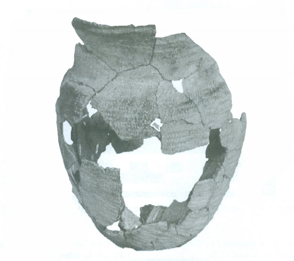
Kinzua Phase Pot found in Cold Spring, New York and curated by the Seneca Iroquois

National Museum Salamanca, New York. (Myers, 2019)


The National Park Service sponsored survey and testing in the area that would be inundated by the Allegheny Reservoir in September and October of 1958 by William A. Ritchie (New York State Museum) and Don W. Dragoo (Carnegie Museum).  Most of the initial survey was confined to surface testing because the land was still privately owned and much of it was being actively farmed.  After the land   was purchased by the U.S. Government, a more thorough investigation could be conducted.  One site of particular interest was the Kinzua site (36WA0053).  Only a few chert flakes (debitage) had been found at this location during the initial surface survey.

Stanley Lantz of the Carnegie revisited the site in 1965, as the dam was nearing completion.  A large portion of the site had already eroded away by the lapping waters of the rising reservoir, revealing pottery sherds associated with the Allegheny Erie Tradition (A.D.1100-1300) (Lantz 2020).  Full scale excavations commenced in 1965 with the mechanical removal of topsoil exposing the precontact indigenous occupation.  The remaining portion of the site, approximately 1,200 m2, was excavated and found to be a stockaded village complete with houses, hearths, storage pits and artifacts attributed to a community whose economy was based on agriculture, hunting, and fishing.  The Kinzua site, like many other sites within the Allegheny Reservoir  impoundment area are now under water.  Thankfully a few of them were thoroughly excavated with National Park service funds providing a window into Pennsylvania’s past. 

Tropical Storm Agnes’s effects in western Pennsylvania were devastating but they were less severe than they might have been due to construction of flood control projects following the deadly St. Patrick’s Day flood 36 years earlier. The construction of similar flood control projects in central and eastern  Pennsylvania were not implemented, for the most part,  until after those communities suffered the wrath of Agnes.

If you missed our Learn at Lunch program on the impact of Agnes on cultural resources,  the link is provided here to watch the recorded program.


References:

Dragoo, Don W.

1965       Archeological Investigations in the Kinzua Area of the Allegheny Basin of Western Pennsylvania During 1965, Manuscript on file, The Pennsylvania State Museum Section of Archaeology, Harrisburg, Pennsylvania.

Lantz, Stanley W.

2020       The Allegheny Erie Tradition. In The Archaeology of Native Americans in Pennsylvania Volume 2 edited by Kurt W. Carr, Christopher A. Bergman, Christina B. Rieth, Bernard K. Means, and Roger W. Moeller, pp. 465 – 482, University of Pennsylvania Press.

Mayer-Oakes, William J.

1955       Prehistory of the Upper Ohio Valley; An Introductory Archeological Study. Carnegie Museum Anthropological Papers, No. 2. Pittsburgh, Pennsylvania.

McConaughy, Mark A. and Janet R. Johnson

2003       Sugar Run Mound (36Wa359) and Village (36Wa2): Hopewell/Middle Woodland in Warren County, Pennsylvania. Foragers and Farmers of the Early and Middle Woodland Periods in Pennsylvania, Recent Research in Pennsylvania Archaeology, No.3, PHMC, Harrisburg, Pennsylvania.

Myers, Andrew J.

2019       The Cold Spring Pot: An Allegheny Erie Tradition Vessel Found in the Upper Allegheny Drainage. In Pennsylvania Archaeologist 89(1):25 – 44.

Making History: The Heinz History Center Blog

https://www.heinzhistorycenter.org/blog/western-pennsylvania-history/st-patricks-day-flood-1936


https://www.heinzhistorycenter.org/blog/fort-pitt-museum/hurricane-agnes-and-the-fort-pitt-museum


Online Resources:

https://www.sunburyfloodcontrol.com/The%20Floods%20of%201936%20and%20the%20Copeland%20Flood%20Control%20Bill.pdf


https://www.alleghenyfront.org/the-complicated-history-of-the-kinzua-dam-and-how-it-changed-life-for-the-seneca-people/

https://www.wgrz.com/article/sports/outdoors/the-tragedy-of-the-kinzua-dam/71-445448395

https://triblive.com/local/valley-news-dispatch/50-years-ago-hurricane-agnes-left-indelible-mark/

https://americanindian.si.edu/nationtonation/treaty-of-canandaigua.html

https://scalar.usc.edu/works/ohiyo/index


For more information, visit PAarchaeology.state.pa.us or the Hall of Anthropology and Archaeology at The State Museum of Pennsylvania .

Friday, July 1, 2022

Agnes’ Impact on the Middle Susquehanna River Valley

Summer has begun, and hurricane season is in full swing. As we keep a wary eye on the storms developing over the Atlantic, we continue to look back 50 years ago as tropical storm Agnes made land fall over Pennsylvania. As discussed in prior posts in our Agnes series, destruction of property and lives was intense with tropical storm Agnes in Pennsylvania, leaving homes and businesses in disrepair. Agnes imposed tremendous stress on the federal budget with the passage of the Agnes Recovery Act which allocated nearly two billion dollars for the relief effort to Pennsylvania alone. This led to changes in flood disaster protection measures and the creation of Federal Emergency Management Agency (FEMA) (Grumbine 2017). Today we are looking at the results of Agnes’ fury in the middle section of the Susquehanna River Valley. 

Map identifying the Middle Susquehanna Valley affected by Agnes discussed below.


June 25, 1972, just two days after the flooded Susquehanna River crested at 34.1 feet in Williamsport, Pennsylvania an industrious doctoral archaeology student set out to survey the region. William H. Turnbaugh, a driven Ph.D. student, watched as the smaller tributaries to the Susquehanna subsided and drained quickly into the river due to the steeply pitched watershed, not allowing the river to recede (Turnbaugh 1977). Attributed to the 1955 levee system built in Williamsport and South Williamsport these cities managed to escape much of the extensive damage towns and cities further down and up the river sustained. Deserted towns full of muddy homes, shops, and churches stood as waters receded and those who fled the surging waters could return (Turnbaugh 1977). Roads were impassable, debris from homes and businesses strewn everywhere, and farms fields and crops were destroyed.  

Flooding in Lewisburg, Pennsylvania along Bull Run due to Tropical Storm Agnes. Image from https://susquehannavalley.blogspot.com/2020/06/the-1972-flood-photos-of-lewisburg-pa.html.


Flooding in Selinsgrove, Pennsylvania due to Tropical Storm Agnes. Image from Pennsylvania State Archives. 


Once the waters began to recede, Turnbaugh quickly realized the most visible result of the flooding on archaeological sites was erosion. After extensive survey throughout Lycoming County, three main types of erosion were identified as affecting numerous archaeological sites. The first form of erosion Turnbaugh identified is channel erosion, this is where small streams would cut across areas to create shortcuts around their natural loops creating channels through the soil. Sites that Turnbaugh identified as having been channel eroded include Precontact sites 36Ly11, 36Ly45, 36Ly99 and 36Ly146, all of which were nearly destroyed by channel erosion (Turnbaugh 1977).  

The Late Woodland site (450- 1,100 years ago) 36Ly146 had a channel running about 500 feet through it with depth up to three feet deep and a large portion had been washed away. Due to the flood damage and large amounts of deposited sand and stone very little was found on this site. A few Clemson Island pottery sherds, believed to be from a single pot, were the main archeological find at this site after the flooding (Turnbaugh 1972c).


Pottery sherds found at 36Ly146. Image from the collections of The State Museum of Pennsylvania.

The second type of erosion Turnbaugh identified is pothole erosion, this is where potholes are created in the ground from eddy currents burrowing. The site most significantly affected by this form of erosion the multi-component Precontact site 36Ly74 (450- 10,000 years ago), where a 75 ft x 50ft x 5ft deep pothole was created (Turnbaugh 1977). Artifacts recovered from this site during the 1972 survey included projectile points, net weights, and a trade bead.

A netsinker, trade bead and a bifurcate projectile point recovered from 36Ly74. Image from the collections of The State Museum of Pennsylvania.


The third form of erosion identified by Turnbaugh is sheet erosion, this is where soils are evenly eroded across a large area. A few of the sites affected by this form of erosion include the Archaic (11500-4850BP), Woodland (450- 2,950 years ago), and historic sites 36Ly83 and 36Ly86. The Cliffside site, 36Ly86 (450- 10,000 years ago), had 90% of the site exposed by the flood, allowing for numerous precontact artifacts such as stone tools and projectile points to be found during a surface collection (Turnbaugh 1977). William Turnbaugh recorded and updated numerous sites in north-central Pennsylvania following the Agnes flooding, but this was just the beginning, as a larger survey sponsored by the Pennsylvania Historical and Museum Commission continued this work later in the year (Smith 1977).

Artifacts recovered from the Cliffside site, 36Ly86. Image from the collections of The State Museum of Pennsylvania.


The narrow valleys upriver from Williamsport on the West Branch of the Susquehanna also caused extensive flooding. Sinnemahoning Creek crested at 19.5 feet, flooding this region, and flowing downstream into the Susquehanna. This and other creeks and streams in this narrow valley caused the waters to surge into the river at pinch points flooding the areas that the streams and creeks led to while also causing waters to rise further down river. In Renovo, Pennsylvania the water rose and crested at 26.6 feet and in Lock Haven, Pennsylvania, the water crested at 31.3 feet leading to significant flooding in both areas (National Weather Service 2017).  With widespread flooding in this region, erosion occurred leading to additional archaeological finds. Included in these finds are the Martin Whitcomb site (36Cm2), 36Cn49, and the Ramm site (36Cn44).

The Martin Whitcomb site, 36Cm2 spans from the Archaic through the Woodland (450- 10,000 years ago). After the flooding from Agnes receded artifacts such as projectile points, netsinkers and other stone tools were found. 

Stone tools and projectile points recovered from the Martin Whitcomb site, 36Cm2. Image from the collections of The State Museum of Pennsylvania.


The Ramm site, 36Cn44 is a Late Woodland site (450- 1100 years ago). Flooding from Agnes led to deep grooves along the rows of planted crops up to several inches deep.  Numerous artifacts were found after the water receded including Clemson Island pottery sherds, triangular and other points (Turnbaugh 1972a).

Artifacts recovered from the Ramm site, 36Cn44. Image from the collections of The State Museum of Pennsylvania.


The Archaic through Transitional (11500-2800BP) site, 36Cn49, near Lock Haven, Pennsylvania also incurred extensive erosion due to Agnes. This site produced projectile points, steatite artifacts, netsinkers and other stone tools (Turnbaugh 1972b).

Artifacts recovered from 36Cn49. Image from the collections of The State Museum of Pennsylvania.


Down river from Williamsport, flooding was extensive as smaller tributaries surged from their banks and inundated the towns, cities, and the river. Lewisburg, Harrisburg, and numerous towns between were overwhelmed with flood waters. As in Lycoming County, Northumberland, Union, and Dauphin County archaeological sites were discovered and further explored after the waters receded. Landowners, archaeologists, and amateurs worked together to record and collect on sites. Some of the additional sites found during the year following Agnes include Pre-contact sites 36Nb6, 36Nb8, 36Nb10, 36Nb61, 36Un10, and 36Da30. The Berrier Island site, 36Da30 (450- 2,950 years ago), was severely eroded by Agnes at the northern tip and western edge of the island, with approximately 75 feet of the western edge washed away (Douts 1976).

Flooding of the Governor’s mansion in Harrisburg, Pennsylvania due to Tropical Storm Agnes. Image from Pennsylvania State Archives.  

Along with sites found directly due to flooding and erosion, additional sites were uncovered or updated in the process of flood mitigations. One of these sites includes the Bull Run site, 36Ly119 (450- 10,000 years ago), in Loyalsock Township found during an archaeological survey for the proposed project to utilize the Williamsport Beltway roadbed to double as a levee (North Atlantic Division Corps of Engineers, 1989). After extensive excavations at the Bull Run site, it was found that a fortified village was located there. Due to plowing activities and erosion, all occupation levels from Early Archaic to Late Woodland (450- 10,000 years ago) were in the top 10-12 inches of soil, indicating that only the bottoms of features remained intact (Bressler 1978). The few artifacts found on the site represent small bands of people moving through the area until the Shenk’s Ferry village was erected. Features in the Shenk’s Ferry Village that were discovered included a stockade and trench, pits, hearths, and post molds indicating the location of houses. One feature that is usually indicative of Shenk’s Ferry villages that was not present, are keyhole structures. This is thought to be the result of the missing topsoil from erosion and plowing (Bressler 1978).

Artifacts recovered from the Bull Run Site, 36Ly119. Image from the collections of The State Museum of Pennsylvania.


Another site that was uncovered due to post flooding mitigations is the West Water Street site, 36Cn175 (200- 16,000 years ago). This site in Lock Haven, Pennsylvania, is located upstream from the confluence of the West Branch of the Susquehanna and Bald Eagle Creek causing this area to be prone to flooding (Custer et al. 1994). In 1979 the Army Corps of Engineers established a flood protection plan around Lock Haven, but it wasn’t until the early 1990’s that the plan began to be implemented. At the time archaeological work was done along the site the plan of building a 17.7 foot high, and 100-foot-wide base levee was in place (Custer et al. 1994).

Lock Haven Levee and William Clinger Riverwalk in 2014. 

In the process of preparing for the new levee to be built archaeological surveys were performed, which is how the West Water Street site (36Cn0175) was found. Additional excavations were conducted on the site, resulting in the discovery of artifacts and features spanning from the Paleoindian period (10,000- 16,000 years ago) through the Contact period (about 300-450 years ago). Features such as house patterns, post molds, a stockade, hearths, and storage pits were all found on the site. Numerous forms of projectile points and pottery, clay pipe fragments and stone tools, spanning the long period of time this site had been in use, were all recovered.  

Late Archaic (4850BP - 6850BP) to Middle Woodland (1000BP – 2400BP) projectile points recovered from the West Water Street site, 36Cn175. Image from the collections of The State Museum of Pennsylvania.


Pottery recovered from the Clemson Island (450- 1100 years ago) living surface at the West Water Street site, 36Cn175. Image from the collections of The State Museum of Pennsylvania.


Flooding is a continual issue for Pennsylvania and erosion continues to play a serious role in the loss of archaeological resources. Thanks to the landowners, amateur archaeologists, and professional archaeologists alike, our cultural heritage is being recorded and preserved. Numerous sites, beyond what are listed here, have been recorded thanks to these dedicated individuals. Please help us continue to preserve our past for the future by contacting your StateHistoric Preservation Office (SHPO) with any information regarding cultural resources and their locations.   

Our series on Agnes will continue over the coming weeks as we move across the Commonwealth and into the Lower Susquehanna Valley.  If you missed our Learn at Lunch program on the impact of Agnes on cultural resources, you can watch the recorded program

References:

Bressler, James P.

1978       Excavation of the Bull Run Site in Loyalsock Township, Lycoming County, Pennsylvania. Report submitted to Pennsylvania Department of Transportation Montoursville, Pennsylvania.


Custer, Jay F., Scott C. Watson, and Daniel N Bailey

1994       Data Recovery Investigations of the West Water Street Site 36Cn175 Lock Haven, Clinton County, Pennsylvania. Prepared for U.S. Army Corps of Engineers, Baltimore District. On file at The State Museum of Pennsylvania, Section of Archaeology.


Douts, C.

1976 36Da30: Berrier Island Pennsylvania Archaeological Site Survey Form. PA-Share, https://share.phmc.pa.gov/pashare.


Grumbine, Frank

2017      Inundation of the Heartland Tropical Storm Agnes and the Landscape of the Susquehanna Valley. Electronic document, https://pa-history.org/wp-content/uploads/2018/09/Grumbine-Pencak-Paper-2017.pdf, accessed June 3, 2022.


National Weather Service

2017       Hurricane Agnes: The 45th Anniversary. Electronic document, https://www.weather.gov/ctp/Agnes, accessed June 23, 2022.


North Atlantic Division Corps of Engineers,

1989      1989 Water Resources Development in Pennsylvania. Report on file at the University of Virginia Law Library.


Smith, Ira F.

1977       The Susquehanna River Valley Archaeological Survey. Pennsylvania Archaeology 47(4):27-29.


Turnbaugh, William H.

1972a    36Cn44: Pennsylvania Archaeological Site Survey Form. PA-Share, https://share.phmc.pa.gov/pashare.

Turnbaugh, William H.

1972b    36Cn49: Pennsylvania Archaeological Site Survey Form. PA-Share, https://share.phmc.pa.gov/pashare.


Turnbaugh, William H.

1972c     36Ly146: Pennsylvania Archaeological Site Survey Form. PA-Share, https://share.phmc.pa.gov/pashare.


Turnbaugh, William H.

1977       Man, Land And Time: The Cultural Prehistory and Demographic Patterns of North-Central Pennsylvania. The Lycoming County Historical Society. UNIGRAPHIC, INC., Evansville, Indiana.


For more information, visit PAarchaeology.state.pa.us or the Hall of Anthropology and Archaeology at The State Museum of Pennsylvania .