Showing posts with label underwater archaeology. Show all posts

Monday, May 2, 2022

Hurricane - Tropical Storm - The Destructive Path of Agnes


Fifty years ago, during the summer of 1972 a natural disaster, struck the eastern United States that would leave a lasting impact on communities, disaster reporting systems, and flood control projects from Florida to Maine.  This week we are launching a series of blogs on the path of destruction from Hurricane Agnes as it was known when it made landfall in Florida on June 19th and its downgrade to a Tropical Depression as it moved slowly up the eastern seaboard.  The storm intensified off the coast of Virginia and was close to hurricane magnitude when it moved north, dumping rainfall between 10-19 inches across Pennsylvania, Maryland, and New York from June 21st through June 23rd.  The highest recorded rainfall occurred in Western Schuylkill County, Pennsylvania (19 in.).  Agnes released a deluge which quickly inundated streams and rivers, bringing with them flooding beyond imagination.  The National Weather Service reported a record $3.5 billion of property damage and 118 people died in Agnes’s path.  

This image depicts the storm track and rainfall for Agnes. Source: Hydrometeorological Prediction Center/ NOAA


Pennsylvania’s rivers and streams were already swollen from heavy rains the previous week and the saturated ground couldn’t absorb the impact of this constant rainfall. The Susquehanna River Basin and Schuylkill River Basin, located within the Delaware River Basin on this map, were significantly impacted by flooding.  In the Susquehanna River Basin, the Tioga River flows north into New York where it enters the Chemung River, the Chemung flows southeast back into Pennsylvania through Bradford County where it joins the Susquehanna River.  This entire region was heavily impacted by the flooding which required assistance from the National Guard to evacuate homes and maintain security. 


Map of Pennsylvania’s Major River Basins, Department of Conservation and Natural Resources. Note the red ovals indicating the Tioga, Susquehanna, and Schuylkill Rivers headwaters. 


During the days that followed, scenes of destruction left Pennsylvania residents in disbelief. Nature had shown its force as tons of earth and debris were rearranged by a foot or more of rainfall deposited by Agnes; No part of the state was left untouched by its effects. The worst urban flooding occurred in Elmira, New York and Wilkes-Barre, Pennsylvania.  A dike in Wilkes-Barre was breached and the town was nearly eradicated. Harrisburg in the lower Susquehanna River valley was inundated by high water, the river crested at 33.27 feet, more than 16 feet above flood stage, a record that remains fifty years later.  


https://susquehannavalley.blogspot.com/2020/06/the-1972-flood-photos-of-lewisburg-pa.html


As the floodwaters moved across the landscape, it pushed soils, trees, cars and building debris, uncovering remains of the past which were previously preserved.  In some cases, coffins were dislodged by flood waters and headstones were displaced.  Historic structures were damaged or destroyed leading to new initiatives for recording these resources and implementing flood control projects. 

 As a result of Agnes’s destruction, several archaeological surveys were conducted after the storm. These surveys helped to identify and record archaeological sites and document the landscape changes wrought by one of the costliest natural disasters in Pennsylvania history. This is the first of several blogs that details the impact of Agnes on Pennsylvania’s cultural resources and examined the surveys that took place in the years following the storm, beginning with the work of archaeologist William Turnbaugh. 

Only two days after the waters crested, Turnbaugh began a survey of the area along the Susquehanna River’s West Branch to observe and document cultural resources exposed by the storm. The counties of Lycoming and Clinton in the north-central region of the state were in the initial survey area.  Residents here shared the destruction of their property with surprising ease and allowed him to wander their fields in search of exposed archaeological remains. His findings showed that archaeological sites on the West Branch of the Susquehanna River had been severely impacted by Agnes. This effort would be incorporated into a larger survey of Pennsylvania’s archaeological sites begun later that year and sponsored by the Pennsylvania Historical and Museum Commission (Smith 1977). Turnbaugh’ s dissertation, Man, Land and Time, published in 1977 provided background information on previous surveys, results of his survey, descriptions of ecological settings throughout time, and a chronology for the settlement of precontact people in Pennsylvania.

We hope you will continue to check in with us as we trace the impact of Agnes on the archaeological and historical resources of Pennsylvania.  Take some time to research the impact of this storm on your community as the anniversary date of this event approaches. Many communities are still experiencing flooding episodes, especially flash flood events. These events underscore the importance of emergency preparedness. For information on how you can be ready, check out FEMA’s guide, How to Prepare for a Hurricane. 

For more information, searchour collections, check out PAarchaeology.state.pa.us, or visit the Hall of Anthropology and Archaeology at The State Museum of Pennsylvania .


References

National Weather Service

n.d.        Flood of June 1972 – Hurricane Agnes. Binghamton, NY Weather Forecast Office. Available at: https://www.weather.gov/bgm/pastFloodJune1972 (Accessed April 26, 2022)

 Hurricane Science, the National Science Foundation

n.d.   Hurricanes: Science and Society, University of Rhode Island, 1972 Hurricane Agnes http://www.hurricanescience.org/history/storms/1970s/agnes/

 Smith, Ira F.

1977         The Susquehanna River Valley Archaeological Survey. Pennsylvania Archaeologist 47(4):27-29.

Turnbaugh, William H.

1977       Man, Land, and Time: The Cultural Prehistory and Demographic Patterns of North-Central Pennsylvania. The Lycoming County Historical Society. UNIGRAPHIC, INC. Evansville, Indiana.


For more information, visit PAarchaeology.state.pa.us or the Hall of Anthropology and Archaeology at The State Museum of Pennsylvania .


Friday, August 19, 2011

U is for Underwater Archaeology

U is for Underwater Archaeology, because frankly Underground Archaeology is just a little too redundant, kind of like wet water, or hot fire. Underwater archaeology poses a unique set of challenges to an archaeologist. Changing conditions on the water, delicate precision instruments, and a specialized skill set necessary to use them, make underwater archaeology not only a costly proposition but a potentially hazardous one as well. Not surprisingly, it’s not very often underwater archaeology is conducted in Pennsylvania. Nevertheless, there are a few notable examples where it has taken place.


One artifact collection recently submitted to the State Museum of PA involved an underwater survey of a small portion the Delaware River in anticipation of a runway expansion at the Philadelphia International Airport. Ground penetrating radar and sonar surveys were used to identify areas of interest or “targets” that were later visually inspected with the aid of SCUBA gear. Seen below is a sample of artifacts recovered from the underwater excavation.


earthenware ceramic sherds, dark green glass wine bottle fragment, iron spike, and stoneware bottle  c. mid 19th C.

In his manuscript A Preliminary Survey to Analyze the Potential Presence of Submerged Cultural Resources in the Delaware and Susquehanna Rivers J. Lee Cox Jr. lists over 100 shipwrecks on the Delaware River between 1757 and 1946. Schooners, sloops, tugs and steamers, with names like Mosquito, Yankee Doodle and Sturdy Beggar, succumb to watery graves from collisions with other vessels, boiler explosions, deck fires and crushing winter ice.

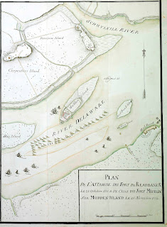
1777 Map of Delaware River

 
One spectacular artifact recovered from the Delaware River in 2007 can be traced back to the Revolutionary War. A cheval de frise, intentionally submerged to obstruct British naval forces from advancing up river, was found in remarkable condition and can be seen at the Independence Seaport Museum, in Philadelphia. The map above illustrates the position of the defensive cheval de frise in the Delaware in 1777.

Moving to the opposite corner of the State, this Snead shallow water diving helmet was recovered off of Presque Isle in Lake Erie, and was donated to the State Museum of PA by John Cutter in 2005. Cast iron in construction, weighing around 60 lbs it dates between 1900 and 1940 and is truly a one of a kind object in the collections of the Section of Archaeology. Not known to be associated with any shipwreck, the helmet is currently on loan to the Erie Maritime Museum.

Snead shallow water diving helmet 1900 - 1940

 
While the notion of searching for sunken treasure has a certain appeal to the adventurer and the romantic alike, it is important to note that that objects recovered from waterways within the state are subject to the State History Code and in fact the property of the Commonwealth.

Reference:

Cox, Jr., J. Lee
A Preliminary Survey to Analyze the Potential Presence of Submerged Cultural Resources in the Delaware and Susquehanna Rivers (1984)
unpublished manuscript on file State Museum of PA, Section of Archaeology

For more information, visit PAarchaeology.state.pa.us or the Hall of Anthropology and Archaeology at The State Museum of Pennsylvania .