
This week, we continue our celebration of the 50th
anniversary of the opening of The State Museum of Pennsylvania in 1965. In
the mid-1960’s, much of the research conducted by the State Museum was focused
on the Susquehanna River basin and especially the Lower Susquehanna basin.
Several power companies were planning construction projects and knowing of the
significant archaeological sites in the region, they contacted the State Archaeologist.
One such project was Metropolitan Edison’s construction of the Three Mile
Island Nuclear Complex consisting of several large cooling towers and
associated buildings, roads and parking areas. With funding from Metropolitan
Edison, the State Museum’s Section of Archaeology conducted a survey of the island
to identify and examine archaeological sites threatened by construction of the
proposed facility. After years of agricultural dormancy, much of the island was
overgrown with dense vegetation making surface conditions difficult for the
archaeologists to study. The island had also suffered from years of erosion
resulting in a mixing of archaeological sediments. Coal silt and sterile soil covered
much of the island making discovery of artifacts nearly impossible. However,
after a difficult survey, the upper part of the island was determined to have
the best potential for the preservation of undisturbed information on the prehistoric
occupation of the island. This was identified as the Three Mile Island site
(36DA50).
After
clearing flood debris and tangled vegetation, museum staff and a small
contingent of college students mapped the intact surface of the site: thereby
establishing a datum point, grid pattern and a series of excavation units.
Forty-nine 5 by 5 foot squares forming three principal excavations were
selected for study and explored for archaeological remains. Two sections of the
cleared area designated as A-D were selected for study, both of which yielded
prehistoric ceramics, stone tools and related stone debitage situated in two
feet of culturally stratified alluvial sediment. Although coarse by todays
standards, the excavations were conducted in arbitrary 6 inch levels.

Excavation
units at 36DA50 facing northwest
The
results document one of the few, Early and Middle Woodland occupations
excavated in the Lower Susquehanna basin. In terms of the regional prehistoric
cultural record, this section of the
Susquehanna Valley appears to be related to the Middle Atlantic Seaboard
Culture Sequence (Stephenson 1963). As such, the prehistoric pottery from Three
Mile Island includes many of the types found in the Coastal Plain and Piedmont Provinces
located south of Harrisburg, Pennsylvania. Ira Smith (1977), however, identified
a number of new ceramic types. Most of these were associated with the local
Early and Middle Woodland occupations whose pottery was useful in defining the
local sequence on the basis of temper, surface treatment and form.
Unfortunately, no sites in the immediate area of Three Mile Island have provided
such information so reliance must weigh with comparisons found in other regions
of the Middle Atlantic where the chronology is better documented (www.jefpat.org/diagnostic/Prehistoric
Ceramics/index-prehistoric.html.)
The
Early/Middle/early Late Woodland Period ceramics recovered at 36DA50 include Ware
Plain; Popes Creek Net Impressed; Accokeek Cordmarked and Clemson Island
Cordmarked (all established types) Light Plain; Light Plain Interior-Exterior
Cordmarked and Susquehanna Cordmarked (all new provisional types). Regrettably,
most of the ceramics were highly fragmented and dominated by body herds making
assignment difficult as to vessel form and accurately identifying the minimum
number of vessels in the sample.

Middle
Woodland Net-impressed pottery

Late
Woodland pottery Clemson Island Cordmarked with punctate
The
stone tool assemblages, specifically projectile points, associated with the
ceramic levels at 36DA50 broadly mirrored typologies of the Middle Atlantic region.
Vernon-like points seem to have a broad spread from Early to Middle Woodland
since they occur with early Marcey Creek wares as well as Popes Creek and other
Accokeek Creek site ceramics. Calvert-like points are known to occur in Late
Archaic contexts, however, they have also been found in Early Woodland Marcey
Creek contexts at such sites as the Marcey Creek and Seldon Island sites
located in the Potomac River valley.

Vernon-like
points
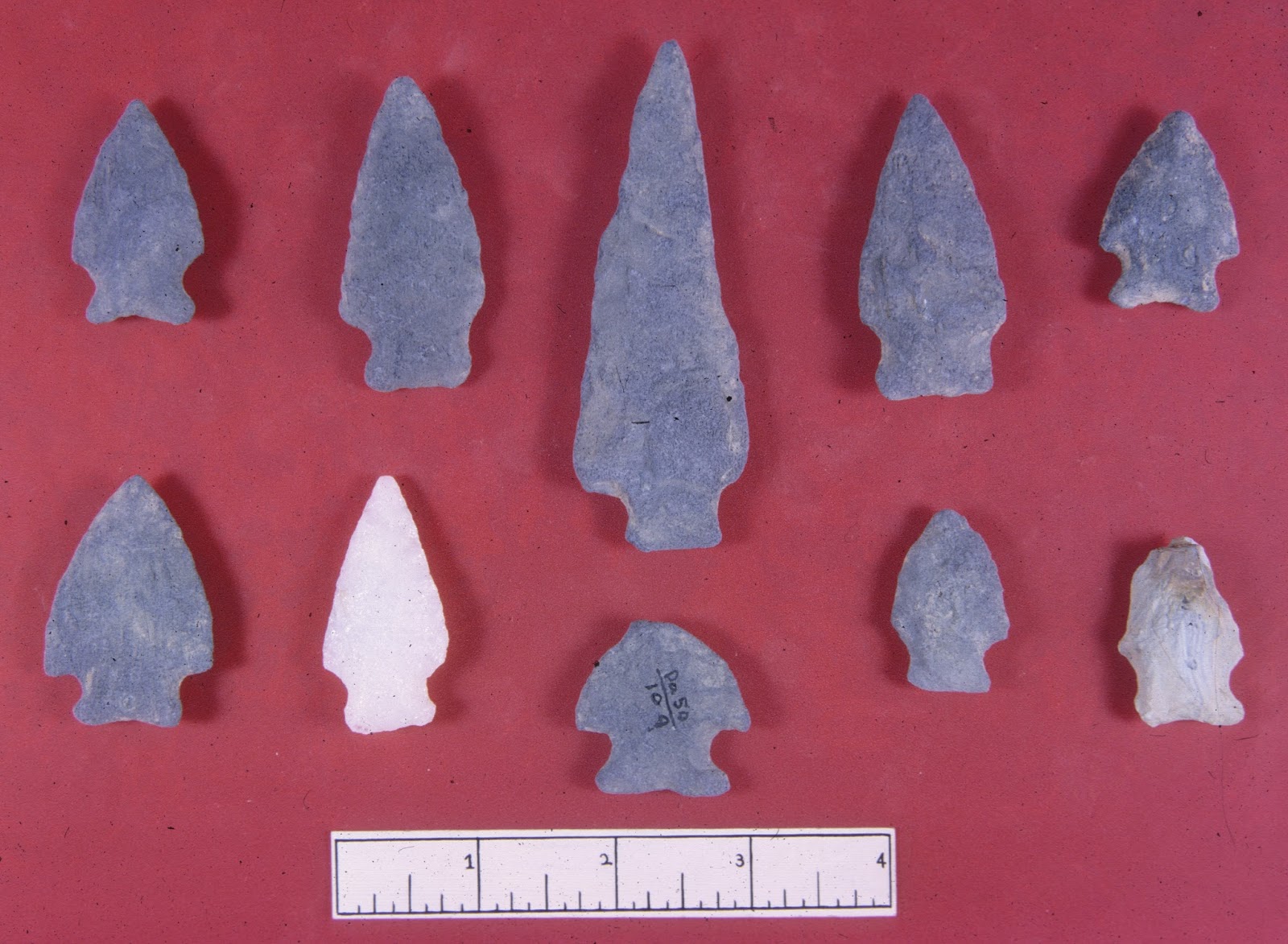
Vernon
and Calvert-like points

Triangular
points
Although
the lithic material was typically quartz, argillite and metarhyolite,
excavations produced a jasper tool cache consisting of 248 worked flakes removed
from six cores. They show considerable
trimming or nibbling along flake edges and other flakes exhibit “utilization
scarring” on one or more of their edges. Many also are well-worn and dulled from
use from cutting things apart. Based on the pattern of edge wear there flake
tools were used on ………. “hard but elastic surfaces such as bone or wood” (Smith
1970). In general terms the flakes display triangular and trapezoidal cross
sections. Equally interesting were the high grade stone tools classified as end
and side scrapers with steep edged working areas. A few of these exhibited
small spurs indicative of graver tools found on scrapers of the Paleoindian
period.

Flake
and Blade tools

Reconstructed
blade/core

End
scrapers from various levels
In
sum, 36DA50 served as a camp site during Late Archaic through early Late
Woodland times. Although no dietary remains were recovered, it is assumed Native
Americans were exploiting wild plants, and animals in a riverine setting. Based
on a few other sites from this period, it is also probable that they were
beginning the process of plant domestication. The Three Mile Island site is
significant because it represents one of the few windows into this time period
of just prior to full plant domestication and the dependence farming as a way
of life.
We
hope you have enjoyed this summary of the archaeology of Three Mile Island and
please join us again for more fascinating topics from the Section of
Archaeology, The State Museum of Pennsylvania.
Further Reading
Smith, Ira F.
1970 A Cache of Utilized Jasper Flake Tools. Pennsylvania Archaeologist 40(1-2):43-52.
1977 Early
and Middle Woodland Campsites on Three Mile Island. Dauphin County,
Pennsylvania. Pennsylvania Historical and Museum Commission, William Penn
Memorial Museum.
Stephenson, Robert L.
Alice L.L. Ferguson and Henry G. Ferguson
1963 The Accokeek Creek Site: A Middle Atlantic
Seaboard Culture Sequence. University of
Michigan, Museum of Anthropology, Anthropological Papers No. 20. Ann Arbor.
Prehistoric Ceramics in Maryland.
www.jefpat.org/diagnostic/PrehistoricCeramics/index-prehistoric.html.


