This Week in Pennsylvania Archaeology comes to you from
archaeologist Robert Bodnar with help from geologist Robert C. Smith II and
archaeologist Hettie L. Ballweber. Mr.
Bodnar and colleagues have been investigating metarhyolite quarries in the
South Mountain area of Adams and Franklin Counties of south-central
Pennsylvania for many years. The following is a preliminary report on their
recent work at one quarry location.
By way of background, metarhyolite (commonly listed as
rhyolite in the older literature) is a metamorphosed volcanic rock found in
different colors, most commonly dark blue or banded but this quarry is located
in the less common, purple variety. The material flakes well and is good for
stone tool manufacture. Native Americans began using it at least 10,000 years
ago and beginning 4000 years ago, it was intensively used and traded in the Susquehanna,
Delaware and Chesapeake Bay drainages. The research presented below is the
initial step in understanding how groups of Native Americans used these
quarries and how this material was distributed throughout the Middle Atlantic
region.
Mr. Bodnar can be contacted at bodbl@comcast.net
with any questions you might have. We hope you enjoy this presentation.
Seeing Purple: Archaeological Investigations of a Prehistoric
Metarhyolite Quarry on South Mountain in Adams County, Pennsylvania.
On June 16, 1994 an article was published in the Gettysburg
Times titled: County’s First Industry: Rhyolite Richness. It was written by the
late Dr. Louis S. Morgan of Wichita, Kansas. Morgan grew up on a farm in Adams
County, Pennsylvania and attended high school in Gettysburg. It was during his
childhood that he was expected to follow behind his family’s horse-drawn plow. During
this arduous task, he had fun collecting the prehistoric artifacts (he notes sometimes
made from purple rhyolite - aka metarhyolite) that the plow would turn up.
 |
| Presumed Selby Bay/Fox Creek Point (purple). Possibly, manufactured from metarhyolite that originated from the South Mountain quarry currently under investigation. (Morgan Collection, Adams County Historical Society #127). Photo scale rectangles are 1 centimeter long. |
The metarhyolite stone artifacts (spear points, etc.) that
Dr. Morgan happily collected were the finished products of an industrial process
that began at one of the prehistoric metarhyolite quarries that dot the
landscape on South Mountain in Adams and Franklin Counties in Pennsylvania.
A prehistoric quarry, as defined by George Odell, is a specific location
on a landscape at which a lithic resource was extracted. They are usually
characterized by huge quantities of waste material resulting from this process.
Such is the case with the metarhyolite quarry (designated as 36AD0576 in the
Pennsylvania Archaeological Site Survey files managed by the State Historic
Preservation Office, of the Pennsylvania Historical and Museum Commission) now
under investigation on South Mountain. This prehistoric industrial site was initially
identified by the presence of scattered cultural surface material that included
large amounts of purple waste flakes, hammerstones, hammerstone fragments, discoidal
cores, preforms, and their rejected and broken forms – think of all the debris
scattered around a modern limestone quarry. Also visible at the quarry site
were metarhyolite outcrops that included a large float boulder (a large block
of stone that has broken away from the bedrock). Some of these boulders show
signs of being culturally modified or worked. Initially, two discernable quarry
pit features (large shallow depressions in the ground surface) were also
observed. These two pit features were circular in nature and measure
approximately 9’ and 25’ in diameter, respectively. A field investigation was
initiated with permission from the owner. During the summer of 2019 an east/west Trench,
1, was excavated through the center of the 9’ quarry pit and beginning in June
of 2020 an east/west Trench, 2, was excavated through the center of the larger
25’ quarry pit. The following is a preliminary report of the initial results of
the 2019/2020 excavations although the excavations and analyses are still
ongoing.
 |
Trench 2 looking west across the approximate 25’ quarry
pit feature. A large culturally impacted metarhyolite float boulder approximately
5’6” long and 1’6” thick protrudes from the northern wall. Hammer mark scars
are visible on the radius of the exposed float portion and numerous large
diabase hammer fragments, sometimes greater than 18lbs., were located near the float. |
Based on the analysis thus far, it is postulated that a Middle
Woodland, Selby Bay phase (dating 1800 to 1100 years ago), single component quarry
site was discovered. Thomas Mayr (1972) first defined the Selby Bay phase characterized
by Selby Bay points. Henry Wright (1973) recorded some variants of the Selby
Bay point (stemmed, lanceolate, and side-notched) among other things. With
respect to the quarry under investigation, Curry and Kavanagh (1991) as well as
Mayr (1972) note that one of the most common Selby Bay traits is their almost
exclusive use of metarhyolite for their flaking material. The Selby Bay quarrymen
traveled from the coastal plain areas to the distant Catoctin and South
Mountains for their desired metarhyolite, although some trading cannot be ruled
out. A radiocarbon date of A.D. 410 +/- 30 was obtained from Trench 1 in 2019.
The dated charcoal sample was removed from a burning event located near the
bedrock at 93 centimetres in depth. This date fits well within the Selby Bay Cultural
Complex A.D. 300 – 700 (Wright 1973) and A.D. 200 – 900 (Inashima 2008). In
addition to the radiocarbon date, five Selby Bay related artifacts have been recovered
from the two trenches.
 |
| Selby Bay/Fox Creek diagnostics recovered at quarry site 36AD0576. The first two artifacts are from Trench 2 and the third artifact was recovered from Trench 1. The third artifact is also metarhyolite, but not of a metarhyolite type that is known by this author to occur in place near the quarry under investigation. The quarrymen likely brought it with them to the site and then lost or discarded it. |
 |
| Two thinned bifaces recovered in Trench 2 that resemble what Henry Wright called Selby Bay Phase rough metarhyolite bifaces (Wright 1973 Figure 7m). It is possible, based on their thinned forms, that they were used as tools. Edge wear analysis has not been completed. |
Based on the evidence gathered thus far, the Selby Bay quarrymen
were likely following an industrial quarry site procedure consisting of:
material extraction, reduction and removal of low grade material, and
rough-out/preform production (Sullivan and Rozen 1985). Some limited final tool
production also took place. The target “ore” here seems to be an aphanitic phase
of the circa 564 million year old Catoctin Metarhyolite (Aleinikoff et al.,
1995). This formation began as a near surface volcanic flow that was later
metamorphosed forming metarhyolite. The matrix appears to be a dusky purple and
the interstitial igneous flow breccia with various, more reddish hues (personal
communication Smith II, 2020). In Trench 1 the target ore was dusky purple in
the form of buried float slabs near the bedrock interface. In Trench 2 the target
ore seems to be a dusky purple with more reddish hues occurring as float.
 |
Heavily worked float boulder protruding from the
northern wall of Trench 2. The photo
scale is one meter. |
When interpreting the extraction process that took place, research
from Hatch (1993) lends some guidance. His quarry development model proposes
three stages of extraction which seem to fit, with modification, the evidence
that is being uncovered at the current quarry site.
Stage one involves the quarrymen detaching a suitable piece
of material from an exposed bedrock source or simply selecting useable surface
material. Cresson (2015 personal communication) states that the quarrying of
exposed surface material is common during the Middle Woodland period (2100 to
1100 years ago). To aid in the detachment process, large hand held hammerstones
were most likely employed. Hammerstones are the principle quarry tool being found
at the site. Ritchie (1929) states that “the hammer is the tool of tools. No
single implement was more indispensable to primitive man”. The quarry site
hammerstones were made predominantly from diabase, but metarhyolite, quartz,
metabasalt, and quartzite were also observed in decreasing amounts. Most of the
hammerstones are broken and many are very fragmented. Two types of diabase
hammerstones were used. The most common type was medium-grained York Haven
Diabase, and the second type was a fine-grained Rossville Diabase (personal
communication Smith II, 2020). Interestingly, the nearest diabase source is many
miles distant and some of the fragments weigh up to 19 pounds. Tremendous
effort was put forth by the quarrymen just to get the diabase hammerstones to
the site.
 |
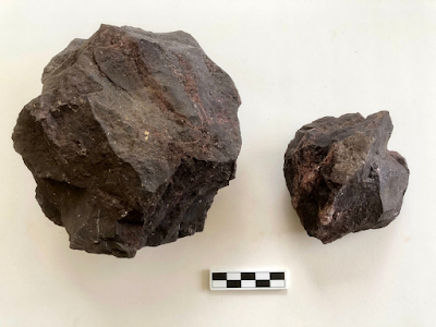
| Diabase hammerstones: 19 pound medium-grained quarry
boulder left, smaller Rossville Diabase pictured |
Stage two of Hatch’s quarry development model would involve
the quarrymen digging around a near surface exposure in order to get at the
targeted ore. Two hoe-like metarhyolite digging tools were recovered from the quarry
excavation which would help with this task. Hatch states that stage two can be
a progression into stage three. That would depend on the surface exposure’s
size, and whether targeted ore was encountered as bedrock.
Finally, stage three, as Hatch describes, would be a progression
to larger, deeper, and more labor-intensive quarry pits.
Initial data from Trench 2 indicates that the quarrymen
began digging at an exposure (stage two) and then followed the targeted ore vertically
and horizontally. As the quarry workers exposed, extracted, and reduced the targeted
ore, they discarded their waste behind them leaving a larger deeper pit (stage
three) filled with the debris of their labor.
Two different reduction technologies (tool making strategies) were likely
being employed at the site: discoidal core reduction (Terradas 2003) and staged
bifacial reduction (Callahan 1979). During the Selby Bay Middle Woodland Period
both technologies were used (Stewart 1992 and Cresson n.d.). Evidence of discoidal
core reduction at the site included numerous discoidal cores, trihedral
platform flakes, and flake preforms.
Basically, this reduction method is straight forward: hit then flip, hit then flip in a circular fashion. When the core is flipped, the flake scar on the reverse side becomes the next striking platform (Clarchaeology 2013).
 |
Example of flake preform (personal communication Nissly,
2020). |
 |
Exhausted discoidal cores were numerous at the site.
Sizes varied from large 11+” in diameter to smaller 2.5” in diameter.
|
The staged bifacial reduction technology is used when the
quarrymen want to reduce a block of stone to a single finished artifact. The
mass goes through a series of steps that includes shaping and thinning.
Unwanted and surplus material is removed during this process creating a lot of
waste (Crabtree 1985).
 |
Evidence of the staged bifacial reduction technology from
the site. |
Dr. Morgan ended his article in the Gettysburg Times with a
hope that his donation of thousands of artifacts (some purple) might someday be
beneficial to a person wanting to learn more about the great rhyolite industry that
drew a distant people, like the Selby Bay, to a place now called Adams County,
Pennsylvania.
References:
Aleinikoff, J.N., Zartman, R.E., Walter, M, Rankin, D.W.,
Lyttle, P.T., and W.C. Burton
1995 U-Pb ages of metarhyolites of the Catoctin
and Mount Rogers Formations, central and southern Appalachians: Evidence for
two pulses of Lapetan Rifting, American Journal of Science, v. 295, p. 428-454.
Callahan, Errett
1979 The Basics of Biface Knapping in the Eastern
Fluted Point Tradition: A Manual for Flintknappers and Lithic Analysts.
Archaeology of Eastern North America 7(1):1-180.
Clarchaeology
2013 August, 24 Discoidal Core Reduction (with
commentary) by Dr. Chris Clarkson.
https: //youtu.be/6tbuczKX864.
Crabtree, Don, and John D. Speth
1985 Experiments in Flintworking Vol. II. Special
Publication # 10. Experiments in Replicating Hohokam Points. Vol. 16: 1 (1974)
Reprinted From Tebiwa.
Cresson, J.
N.D. Fox Creek Reduction Strategies. Ms.
available through the author, Moorestown, New Jersey.
Curry, Dennis C.,
and Maureen Kavanagh
1991 The Middle to Late Woodland Transition in
Maryland. North American Archaeologist 12(1): 3-28.
Hatch, James W.
1993 Research into the Prehistoric Jasper
Quarries of Bucks, Lehigh and Berks Counties, Pennsylvania, Report submitted to
the Pennsylvania Historical and Museum Commission, Harrisburg, PA.
Inashima, Paul Y.
2008 Establishing a Radiocarbon Data Based
Framework for Northeastern Virginia Archaeology. Quarterly Bulletin of the
Archaeological Society of Virginia 63(4): 251
Mayr, Thomas
1972 Selby Bay in Retrospect. Maryland
Archaeology 8(1):2-5.
Odell, G.H.
2004 Lithic Analysis. New York: Springer.
Ritchie, W.A.
1929 ‘Hammerstones, Anvils, and Certain Pitted
Stones’. In L. H. Morgan Research and Transactions of the New York State
Archaeological Association VII, 2.
Stewart, R.
Michael
1992 Observations on the Middle Woodland Period
of Virginia: A Middle Atlantic Region Perspective. In Middle and Late
Woodland Research in Virginia: A Synthesis, edited by Theodore R. Reinhart
and Mary Ellen N. Hodges, pp. 1-38. Archaeological Society of Virginia, Special
Publication No. 29.
Sullivan, A. P.,
III and K. C. Rozen
1985 Debitage Analysis and Archaeological
Interpretation. American Antiquity 50:755-779.
Terradas, X.
2003 Discoid flaking method: Conception and
technological variability. In M. Peresani (ed.), Discoid Lithic Technology:
Advances and Implications, pp. 19-31. BAR International Series 1120.
Oxford: Archaeopress.
Wright, Henry T.
1973 An Archeological Sequence in the Middle
Chesapeake Region, Maryland. Maryland Department of Natural Resources,
Maryland Geological Survey, Archeological Studies No. 1.
For more information, visit
PAarchaeology.state.pa.us or the Hall of Anthropology and Archaeology at
The State Museum of Pennsylvania .


