The folks that faithfully bring you "This Week in Pennsylvania Archaeology" every Friday are spending the holidays with friends and family. From all of us to all of our readers, we hope you had a very Merry Christmas, and will have a Happy New Year! Next stop, the 2014 Pennsylvania Farm Show!
For more information, visit PAarchaeology.state.pa.us or the Hall of Anthropology and Archaeology at The State Museum of Pennsylvania .
Friday, December 27, 2013
Friday, December 20, 2013
Washington County


This week in Pennsylvania Archaeology takes us to Washington
County located in the southwestern corner of Pennsylvania. Washington County is
bordered by the Monongahela River on the east, Greene County to the South, West
Virginia state border on the west and Beaver and Allegheny counties on the
north.
On March 28, 1781 Washington County was formed from part of Westmoreland
County. It was named after our American Revolutionary War leader and father of
our country, George Washington. The county contains 861 square miles and its seat is Washington, Pennsylvania.
The physiography and geology of Washington County is shared
by many of the surrounding counties in southwestern Pennsylvania and West
Virginia. Washington County is in the Waynesburg Hills Section and the
Pittsburgh Low Plateau Section of the Appalachian Plateaus Province which
consists of Permian and Pennsylvanian geologic periods (250-330 million years
old). Much of the bedrock geology is comprised of shales, limestones and
sandstones of various types. Some of the largest soft coal deposits underlay
these formations and are economically important to much of southwestern
Pennsylvania. The Monongahela River, with its many locks and dams, is used to
barge the coal down river to Pittsburgh and beyond.
The general topography
of Washington County is characterized by gently rolling hills on its eastern half
and , for the most part, rugged hills on its western half where the terrain consists of
dissected valleys and somewhat narrow floodplains. With the exception of a small
area on the west and an equally sized area on the north that drains to the main
Ohio River, the creeks flow eastward to the Monongahela River which joins the
Ohio River system at Pittsburgh. There, the principal watercourses include Ten
Mile, Pigeon and Chartiers Creeks, the latter of which is the largest.
Chartiers Creek, named after Peter Chartiers, whose mother
was likely Shawnee, had a trading post on or near the mouth of Chartiers Creek
at present day McKees Rocks. Peter who sided with the French and their Indian
allies on the Ohio frontier was also a fur trader and Indian-White interpreter
during that period of political turmoil in the Ohio valley.
During the 18th century there were three notable
Indian paths that ran through Washington County, all of which intersected at
Washington, Pennsylvania and connected with other pathways along all four
cardinal points of the compass.

The Catfish Path, from Wallace (1965)
The Catfish Path was so-named after the Delaware Indian,
Tingoocque (translated as) “Catfish” (Wallace 1965). The path ran north along
Chartier’s Creek and joined with other Indian paths at the Delaware town of Shannopin
(Donehoo 1928) at present day Pittsburgh. South of Washington the path crossed both
branches of Ten Mile Creek then on to join the Warriors Branch Path near
present day Waynesburg, Pennsylvania.
The Glades Path joined with the Ohio River at present day
Wheeling , West Virginia and extended eastward to the Raystown at present day
Bedford, Pennsylvania. Traveling the path required one to ford the Youghiogheny
River at West Newton, Pennsylvania. Other lesser waterways and mountains would
have been encountered on the way between present day Somerset and the Juniata’s
Raystown Branch. A 1797 entry in John
Heckwelder’s journal states that “ this road [Glades Indian path] is said to be
best in summer during dry weather, when both Mountains are also easy of ascent”
(Wallace 1965).
The Pennsylvania Archaeological Survey (PASS) files lists
1421 prehistoric and 166 historic sites bringing the total to 1556 recorded
sites for Washington County. This is a
rather high site density of one site for every .55 miles. A review of the list
shows that 2/3rds of the sites are located in upland settings as opposed to
lowland (i.e. floodplain, terrace, island etc.) settings. Most of the upland
settings are hilltops, benches and saddles (low points between two higher
points).

variety of chert types and projectile points from the George Fisher collection
Cherts of various types were the preferred lithic material
used by prehistoric peoples living in the pre-Washington County area. Not
surprising, the dominant cultural stages based on projectile point types
present at these sites characterized the Late and Middle Archaic periods
(4,300-9,000 years ago). Projectile points representative of the Early, Middle
and Late Woodland periods followed these next in number. The Transitional and
Paleoindian periods are last with 11 and 14 recorded sites, respectively.

hematite celts from Washington County
Historic period sites are few in number when comparisons are
made with the number of recorded prehistoric sites. Only 81 sites indicative of
this period are known and largely include domestic/farmsteads and
commercial/industrial component sites. Whatever the reason(s) the emphasis to
report sites has been focused on reporting prehistoric sites of the foregoing
eight recognized cultural periods.

cannel coal and slate pendants from Washinton County
The region in and around Washington County has been of
interest to antiquarians and archaeologists for many decades past. George Fisher,
an amateur archaeologist and collector from Finleyville, Pennsylvania single
handedly located and investigated a large number of prehistoric sites dating to
the Woodland period (2100 - 450 years ago). The notes and photographs that
survive chronicle an active period in his site investigation career from the
1920’s through the 1940’s largely based on Monongahela villages in the
southwestern Pennsylvania region. Fisher was especially active in many parts of
Allegheny, Washington, Westmoreland and Fayette counties south of Pittsburgh
and his report to the Pennsylvania Archaeologist illustrates these activities (Fisher
1930).
In 1973, a team of specialists from the University of
Pittsburgh led by James Adovasio commenced excavations at the Meadowcroft
Rockshelter located near the small village of Avella, Washington County. Meadowcroft is a dry rockshelter formed from part of a large sandstone
cliff of Morgantown-Connellsville sandstone.It is a smaller part of the
larger Casselman Formation typical to Washington County’s Cross Creek drainage.
The contents of the rockshelter were sealed over many thousands of years by the
down slope movement of colluvial sediments. These sediments sealed an
incredible cultural record dating back to
approximately 16,000 years ago (cf. Adovasio et.al. 1975; 1977).

Map of SW Pennsylvania showing location of Meadowcroft and surrounding region
Over subsequent years, the team of specialists uncovered a multi-layered
sequence of intact cultural deposits dating from the pre-Clovis through
Historic periods which qualified the site as one of the most continually
occupied archaeological records in North America. Meadowcroft Rockshelter was
deemed so important that it was recognized worldwide and listed as a National
Historic Landmark and World Heritage Site. Meadowcroft Rockshelter is the main
feature of interest at Meadowcroft Village where the public can visit the
rockshelter through guided tours.
We hope that you have enjoyed this journey to Washington
County archaeology and encourage you to read additional information provided in
the Reference section of this presentation. Do join us again next week when we
will celebrate the Christmas season with more interesting archaeology facts!
References
Adovasio, James M., Joel D. Gunn,
Jack Donahue and Robert Stuckenrath
1975 Excavations
at Meadowcroft Rockshelter, 1973-1974: A Progress Report.
Pennsylvania
Archaeologist 45(3): 1-30.
Adovasio, James M.; Joel D. Gunn;
Jack Donahue and Robert Stuckenrath. With selections by Jan D. Applegarth,
Ronald C. Carlisle, David T. Clark, David Faingnaert, John E. Guilday, William
C. Johnson, David Krinsley, Kenneth Lord, Esther Skirboll and Paul G. Wiegman
1977 Meadowcroft Rockshelter: Retrospect 1976. Pennsylvania
Archaeologist 47(2-3):1-93.
Donhoo, George P.
1928 A History of the Indian Villages and Place Names in Pennsylvania.
Harrisburg.
Fisher, George S.
1930 Indian Sites and Excavations in Western Pennsylvania. Pennsylvania
Archaeologist 1(2):8-9.
Wallace, Paul A.W.
1965 Indian
Paths of Pennsylvania. Pennsylvania Historical and Museum Commission.
Harrisburg.For more information, visit PAarchaeology.state.pa.us or the Hall of Anthropology and Archaeology at The State Museum of Pennsylvania .
Friday, December 13, 2013
Warren County: Part of the Hopewell Interaction Sphere


This week’s journey by county through the archaeology of Pennsylvania takes us to northwestern Pennsylvania and Warren County. This county is situated in the High Plateau section and the Northwestern Glaciated section of the Appalachian Plateaus Physiographic Province. The region is characterized by rolling uplands and steep valleys. The northwestern half of the county was glaciated and exhibits glacial features such as terminal moraines, kettle lakes, swamps and kame terraces. The Allegheny River cuts through the middle of the county and the major tributaries are Brokenstraw Creek and Conewango Creek.
Warren County was first occupied by
Europeans in the 1740s. Initially, the French claimed the region and documented
their claim with a series of lead plates buried in the ground that stretched
from the City of Warren down the Mississippi Valley. After the French and
Indian War, the British took over and finally the Americans incorporated the
land into the Commonwealth of Pennsylvania. Early on, the major industry was
lumber but the discovery of oil in the 1870’s replaced the logging industry.
Residents of the county prospered in the 19th century but by the
middle of the 20th century the economy was on the decline. A large
section of Warren County is in the Allegheny National Forest and is reserved
for recreation, lumbering and the gas industry.
The density of sites (at 1 site per
1.97 square miles) is relatively high especially compared to other counties in
the northern part of the Commonwealth. There are concentrations of prehistoric
sites along the Allegheny River, at the mouth of the Brokenstraw for example,
but numerous sites have also been recorded in the uplands. Many of these are
rockshelters and 28% of all sites in the county fit this category. Allegheny
National Forest has their own crew of archaeologists and while conducting
surveys in preparation for logging and gas projects, they have recorded many of
these sites.
The most commonly used lithic
material by prehistoric peoples in making stone tools is chert (43%) and 42% of
the sites reporting lithic material specify Onondaga chert. The Onondaga
formation is located in a band extending from Ontario across New York State
approximately 100 miles (160 km) to the north. This is a high quality and
distinctive lithic type that was used throughout prehistory. It is assumed that
Native Americans directly procured this chert from bedrock sources but there is
also ample evidence that they used pebbles and cobbles that were washed into
the region by rivers or pushed into the region by the glaciers.
Although the Allegheny National Forest
archaeologists have conducted the most extensive surveys in the county, there
have been several other major surveys. The regional archaeological survey
program which was conducted between 1979 and 1981 included Warren County and
documented many new sites but was especially productive in updating information
on existing sites. For example the complex of sites known as the Buckaloons was
proposed as a National Register Historic District but has yet to be nominated.
This track of land contains several sites at the mouth of the Brokenstraw Creek
that include occupations from small Paleoindian camps to Late Prehistoric
villages and several Hopewell mounds.


Sugar Run Mound excavation
Warren County contains at least eight
burial mounds dating to the Middle Woodland period and several of these were
tested in 1941 by the Pennsylvania Historical Commission under the direction of
Edmund S. Carpenter and Wesley Bliss. This was part of the Civilian Conservation
Corps (CCC) investigation of mound and village sites in northwestern
Pennsylvania. Interestingly, the excavation of the Sugar Run Mound was
conducted by a crew of Seneca Indians from the Allegheny Reservation. The Sugar
Run Mound site (36Wa359) contained three mounds that slightly overlapped each
other. Although these had been plowed down to almost level with the current
ground surface, it was possible to determine the construction sequence of the
three. There were at least three stone lined crypts, each surrounded by a
cobble pavement. It is believed that the cobbles under Mound Unit #1 were
arranged in the shape of a raptorial bird on one side of the stone lined crypt and
in the shape of a celt on the other side.


Sugar Run Mound plan view
According to McConaughy and Johnson
(2003:114), the three mounds are separated by relatively short time intervals.
Based on the low frequency of exotic trade artifacts and the radiocarbon date
of AD 250 (uncorrected) Mound Unit #1 was the first to be constructed but this
was prior to the local population becoming involved in the Hopewell Interaction
Sphere trade network. Mounds #2 and #3 contained numerous exotic trade
artifacts such as mica, galena, marine shell, copper and Flint Ridge
chalcedony, indicating these mounds date later in time when the local
population was actively involved in the Hopewell Interaction Sphere.
According to McConaughy and Johnson
(2003:114, Sugar Run Mound is part of the Squawkie Hill phase, a local
manifestation of Hopewell. This is found at several mounds in northwestern
Pennsylvania notably Nelson (36Cw58), Irvine (36Wa251-255), Cornplanter
(36Wa242) and Corydon (36Wa1).
Finally, Warren County is the
location of the last Indian controlled track of land in Pennsylvania. This was
known as the Cornplanter Grant. Cornplanter was a Seneca chief who fought
against the United State during the Revolutionary War. However, after the war,
he encouraged peace with the United States.

According to Wallace (1999:167), he
was instrumental in keeping the Iroquois out of the Miami confederacy which
defeated two American armies but was eventually routed by Anthony Wayne at the Battle
of Fallen Timbers in 1794. In response to his peace keeping efforts, Pennsylvania
awarded Cornplanter and his heirs “in perpetuity” 600 acres of land in the
Upper Allegheny Valley just south of the New York state border. This included
his town of Jenuchshadego. Initially, Cornplanter “brought in Quaker teachers,
established schools, made roads, built good houses, encouraged agriculture,
bred large herds of cattle and, in a word, turned the Cornplanter Grant into a
model community” (Wallace 1999:168). Unfortunately, at the end of his life, he
rejected all of this becoming disillusioned with his non-Indian neighbors. He
died in 1836.

Cornplanter
The Cornplanter Grant was occupied by
his descendents and other Indians until 1964, when the remaining residents were
relocated upriver in preparation for the construction of the Kinzua Dam. Cornplanter’s
cemetery was archaeologically excavated (Abrams 1965 and Sublett 1965) and,
along with his monument also re-located. Remembering the words of the original
land grant issued by the Commonwealth “in perpetuity”, the dam project was
strongly opposed by Native Americans; however, the land was flooded in 1967.
This signaled the beginning of a revitalization of Native American culture in
America; an event that was instrumental in the formation of the American Indian
Movement. The flooding also covered numerous archaeological sites including the
Sugar Run mound discussed above.
We hope you have found this journey
through the archaeological heritage of Warren County interesting, and that you
will seek additional reading in the references provided below. Understanding and exploring our
archaeological heritage is crucial to our understanding of human behavior and
our ability to change and adapt over time - just as the peoples of Warren
County have done for thousands of years.
References
Abrams, George H.
1965 The Cornplanter
Cemetery. Pennsylvania Archaeologist
35(2):59-73.
McConaughy, Mark A. and Janet R.
Johnson
2003 Sugar
Run Mound (36Wa359) and Village (36Wa2):
Hopewell/Middle Woodland in
Warren
County, Pennsylvania. In Foragers and Farmers of the Early and Middle
Woodland Periods in Pennsylvania, edited by Paul Raber and Verna Cowin, pp. 101-116. Recent Research in Pennsylvania Number 3,
Pennsylvania Historical and Museum Commission, Harrisburg, Pennsylvania.
Sublett, Audrey J.
1965 The Cornplanter
Cemetery: Skeletal Analysis. Pennsylvania
Archaeologist 35(2):74-91.
Wallace,
Paul A.W.
1999 Indians in For more information, visit PAarchaeology.state.pa.us or the Hall of Anthropology and Archaeology at The State Museum of Pennsylvania .
Friday, December 6, 2013
Venango County


We return this week to our county by county journey through
Pennsylvania’s archaeological heritage with a stop in the northwestern corner
of the state, Venango County. Situated
in the glaciated Appalachian Plateaus Province this physiographic zone contains some of the highest elevations in Pennsylvania. Today the primary drainage is the
Allegheny River, but during Pleistocene glaciations most of the streams and
rivers drained northward into Lake Erie and then into the
Atlantic Ocean via the St. Lawrence Seaway. Ice dams which formed during the
Pleistocene reversed the direction of the major drainages forcing the
directional flow south into the Allegheny River, and the Ohio River drainage
basin. Glacial till contains gravels
of Onondaga chert cobbles, transported from the quarries of western New York.
The
primary lithic material used for stone tool production in Venango County is
chert and there are several local sources in addition to the high quality
Onondaga material. Northwestern Pennsylvania typically receives major snow fall
from the west and cold air masses out of Canada insure temperatures to retain
snow cover for an average of 60 days per year. Forests of oak, maple,
pine and hickory provided prehistoric peoples with food sources from nuts and
seeds to the fauna that inhabited these woods.

biface fashioned from Onondaga chert from the Polk #4 Site (36Ve282)
Four prehistoric settlement types have been defined for Venango County; rock shelters, riverine, upland and special purpose sites. The majority of sites recorded in the
Pennsylvania Archaeological Site Survey (PASS) files are located in upland
settings. Two sites previously reported
on in riverine settings provide important architectural information for Venago County. Three house types were identified by Sue Ann Curtis at sites 36Ve3 and
36Ve50. Type I is defined as a single
circular to oval row of posts that encloses an area from 8 to 12 feet in
diameter. Type II is a circular or oval structure with an attached oval storage
compartment, typically 8 to 12 feet in diameter but as large as 15 to 20 feet.
These oval compartments are often associated with food storage. The third house type is also circular, 8 to
12 feet in diameter, but has an inner row of post molds- essentially a
double wall around all of part of a wall. It is posited that this second row
may have been post supports for a bench which lined the walls of these
structures.
Curtis identified eleven houses at 36Ve50 and two at 36Ve3
and suggested that as many as 20 houses may be present at each of these sites
based on artifact concentrations and additional post molds. Curtis suggests that these camps are central
base or transient camps based on the presence of residential structures,
ceramics, projectile points and stone tools such as grinding stones, net
sinkers, choppers, drills and scrapers. Pottery is described either grit or
quartz tempered with shell tempered pottery present at rock shelter sites. Rock shelters were used seasonally as defined
by faunal remains of turtle, frog, migratory birds and mussel shells. We would
be remiss in not mentioning at this time the Rainbow Rocks Petroglyphs
site. Examined and reported on by James
Swauger of the Carnegie Museum, Rainbow Rocks Petroglyphs are carved on the
north wall of a rockshelter opening, part of the Pottsville sandstone
formation. These pecked and rubbed images illustrate snake figures, bird tracks
and a single human figure. Swauger who made extensive surveys of the Ohio River
Valley petroglyph formations, notes that the human figure at Rainbow Rock is a
stick figure, an unusual form as others are generally full bodied in the Upper
Ohio Valley. The snake and bird figures are common elements on petroglyphs located
across the Commonwealth, including the lower Susquehanna River.

Rainbow Rocks Petroglyphs
These petroglyph sites are considered specialized use sites
as are a series of oil pits identified and recorded in Curtis’s survey of
Venango County. Two to three thousand oil pits have been dug along terraces in the Oil Creek Valley. These pits were present when the region was
explored in the 18th century, and evidence indicates Native peoples
were using them during the Middle Woodland Period (1,100 – 2,100
years ago). Foot paths used by these native groups were identified by Wallace
and include the Cornplanter-Venango Path, Frankstown-Venango Path and the
Venango Path. It seems likely that the
presence of oil near these foot paths played a role in their importance in Native
trade to the west and north.
Many of these oil pits were destroyed during the 19th
century, but some 250 are now protected from development. These pits vary in shape from circular, oval to rectangular; between 6 and 35 feet in length,
2-5 feet deep and enclosed by a ridge of fill some 2-4 ft high. Excavations indicate that pits were dug to a
depth of six to seven feet to the petroleum based gravel- type
sands. Log structures discovered in two of
the pits revealed a crib-like construction related to this oil
recovery activity. Oil extraction would go on to play a larger role in the 19th century as the demand for oil
increased and the industrial revolution emerged

oil pit crib structure
The Venango Path was not only important for native peoples,
but was also an important military highway during the French & Indian War.
The French construction of a portage road from Presque Isle Bay on Lake Erie,
south to Waterford and Fort LeBoeuf allowed for the transport of materials to
French Creek and eventually the Allegheny River. This route was
important for the French who controlled the Louisiana Territory and who needed to
maintain this path from Canada to Louisiana. The French fort constructed here
in 1756, Fort Machault, was located at Franklin, at the junction of French Creek
and the Allegheny River. The British
defeated the French and built their fort at this location in 1760. It was subsequently destroyed during the
Pontiac War in 1763. The Treaty of Fort
Stanwix in 1784 allowed for the settlement of these lands and designated the
area as “Donation Lands”. Donation lands
were set aside by the commonwealth for donation to Pennsylvania veterans of the
Revolutionary War as payment for service.
In August of 1859 the first oil well was drilled on land
owned by Edwin L. Drake, an event that would significantly impact the
area. By 1862 three million barrels of
oil were reportedly produced and the rush to “get rich” drew thousands to the
area. Boom towns which had sprang up
overnight, Boom Towns, only to become abandoned waste land. Pit Hole was one such town. Established in
1865, its population soared to 20,000 in a few months’ hotels and businesses
would cover the town. Plagued by fires
that occurred on an almost weekly basis and the discovery of more productive
wells a few miles away, the population dropped to just 287 by 1870. Three
families remained in 1877 when the borough charter was annulled. Today the Drake Well Museum and associate
groups help to maintain and operate a visitor center at the site of Pit Hole.

Danforth House, Venango County
Archaeological investigations continue to explore the
heritage of this region and the effort of recording many of these sites goes to
the Venango Chapter #30 of the Society for Pennsylvania Archaeology. Chapter members have recorded a half- dozen
sites and updated information on others, much of this done by chapter member
Bill Black. This chapter is very active
at the local level and often presents at the annual meetings of the Society for
Pennsylvania Archaeology. Their interest
in preservation and archaeological heritage are to be commended.

key fob for the Danforth House
We hope you will take some time to read about the
archaeological heritage of your community and take the time to record
archaeological sites that you may know about.
Remember this is your heritage and it is our duty as citizens to strive to preserve the past for the future. Join us next week as we explore Warren County
on the border with New York state and just north of Venango.
Bibliography
Curtis, Sue Ann
The Cultural Ecology of Early Late Woodland, Venango County,
Pennsylvania, Thesis in Anthropology, Pennsylvania State University, December,
1971.
Darrah,
William C.
Pithole, the
Vanished City; A Story of the Early Days of the Petroleum Industry. 1972
Swauger,
James L.
The Rainbow Rocks
Petroglyphs Site, Pennsylvania Archaeologist, Bulletin of the Society for
Pennsylvania Archaeology, September, 1972, V. 42, No. 3.For more information, visit PAarchaeology.state.pa.us or the Hall of Anthropology and Archaeology at The State Museum of Pennsylvania .
Wednesday, November 27, 2013
Happy Thanksgiving

With the Thanksgiving Holiday once again upon us TWIPA
returns this week with a post focused on one of everyone’s favorite topics, food.
Foodways, or subsistence strategies, have long been a topic of interest and
study of anthropologist and archaeologists. By quantifying the number and types
of food remains, archaeologists can determine the percentage of different types
of plants and animals harvested.
The State Museum of PA’s Section of Archaeology receives a
steady flow of artifact collections as a result of Cultural Resource Management
project surveys and excavations. A
recently submitted project involving highway improvements in Montgomery and Philadelphia
Counties recorded four dozen, mostly 19th Century domestic sites. As
a part of the project’s phase II workplan, diet and consumer behavior were
identified as potential research issues for two of the sites that were
considered potentially significant.

typical project area view, with orange flags marking shovel test pit locations
In his report to
PennDoT, Gary Coppock, working at the time for Archaeological & Historical
Consultants, noted, “Archaeological remains can be analyzed for indications of
the patterns of purchasing and consumption of goods by site occupants. Analysis
of faunal remains may show the extent to which wild or domestic animals
contributed to the diet, whether the animals were slaughtered at the site, and
the economic and dietary value of meats consumed by site occupants (Coleman et
al. 1984). Ceramic analyses can also contribute to the understanding of food
consumption habits. A comparison of the relative frequency of flatware and
hollowware forms, for example, has been used to infer the quality of meats used
and in what form they were consumed (Kelso 1984)."

Excavation Unit profile from Woodhaven Road Extension Project
Stepping back in time, the evolution of
foodways began with small populations of Paleoindian hunters and gatherers
exploiting an ice age landscape. Although the quantity of foods was relatively
low, human population was also low and they did not need to develop special
tools or organize a labor force to support themselves. The Archaic Period
represents a plentiful time and human populations quickly grew by efficiently
using all available resources. People developed many new tools to maximize
their collection of food from the environment. As human populations increased,
they began to exhaust the foods of the temperate forest and were forced to
cultivate plants.

Native American
social organization began to change. Humans became more sedentary and
eventually focused on farming to support increasing populations. Social
structure changed to a tribal organization in order to better organize the
labor force necessary for swidden agriculture of corn, beans and squash, often
referred to as the Three Sisters. Both the nature and timing of the arrival of
these domesticates into the Mid-Atlantic region continue to be intensively
studied research topics in archaeology.
Each of the “Sisters” arrived in the Northeast at different
points in time, with squash (Cucurbita
pepo) being the earliest at between 5000 and 2500 years before present
(Hart and Sidell 1997). Next, corn, or
maize, (Zea maize) becomes common in
archaeological settings post-dating roughly 1200 B.P., or about A.D. 700 (Klein
2003). And last to appear in the
archaeological record is the common bean (Phaseolus
vulgaris), at approximately A.D. 1300 (Hart and Scarry 1999). The
application of C-14 and AMS
techniques has proved to be indispensable tools for dating these and a wide
variety of other botanical remains.
Requiring magnification, smaller evidence such as pollen,
starch grains, and phytoliths can be used to identify plant species beyond the
three typical domesticates. These types of analyses can not only help to
identify dietary components of an archaeological site, but also aid more
broadly in paleoenvironmental reconstruction.
Along with zooarchaeological
analysis of faunal remains, proteins recovered from the residue on cookware can
be analyzed to identify groups of animal species and in some instances specific
species. All these techniques aid the archaeologist in creating a more detailed
picture of the past, in this case concerning just exactly what ingredients were used in
preparation of a meal.
We hope this brief overview of foodways and food remains
analysis wets your appetite for an enjoyable Thanksgiving meal with family and
friends.
References:
Coleman, Ellis C., Kevin W. Cunningham, Jim O’Connor, Wade
P. Catts, and Jay F. Custer
1984 Phase III Data Recovery Excavations of the
William M. Hawthorn Site (7NC-E-46), New Churchman’s Road, Christiana, New
Castle County, Delaware. Delaware Department of Transportation
Archaeological Series No. 28, Dover.
Coppock, Gary F.
2002 Phase I and II
Archaeological Survey Report Woodhaven Road Extension Project (S.R. 0063
Sections A06 & A07) Montgomery and Philadelphia Counties, Pennsylvania - prepared for the Pennsylvania Department of
Transportation Engineering District 6-0
Hart, John P. and C. Margaret
Scarry
1999 The Age of Common Beans
(Phaseolus vulgaris) In the Northeastern United States. American Antiquity
64 (4) 653- 658
Hart, John P. and Nancy Asch
Sidell
1997 Additional Evidence for Early
Curcurbit Use in the Northern Eastern Woodlands East of the Allegheny Front. American
Antiquity 62 (3): 523-537
Kelso, William M.
1984 Kingsmill
Plantation, 1617-1800: Archaeology of Country Life in Colonial Virginia.
Academic Press, New York.
Klein, Michael
2003 Of
Time and Three Rivers: Comments on Early and Middle Woodland Archaeology in
Pennsylvania. In Foragers
and Farmers of the Early and Middle Woodland Periods in Pennsylvania, edited
by Paul A. Raber and Verna L. Cowin, pp. 117-129. Recent Research in
Pennsylvania Archaeology, No.3, Pennsylvania Historical and Museum Commission,
Harrisburg, PAFor more information, visit PAarchaeology.state.pa.us or the Hall of Anthropology and Archaeology at The State Museum of Pennsylvania .
Friday, November 22, 2013
Workshops in Archaeology Review

If you are a frequent follower of This Week in Pennsylvania
Archaeology, you would know that this past Saturday, the Section of Archaeology
of the State Museum of Pennsylvania hosted its annual Workshops in Archaeology program. The theme of this year’s program
was the Archaeology of a Troubled Nation
1775-1865. This all day event was comprised of a series of PowerPoint lecture
presentations. Based on the Evaluation Questionnaire, this year’s program
proved to be informative and entertaining for all whom attended.

Noel Strattan and Tom Held of the Bureau for Historic
Preservation were on hand to guide people through the inner workings of the
Cultural Resource Geographic Information System, or CRGIS web portal. Doug
McLearen and Kira Heinrich, also of the BHP, were available to identify all
manner of historic and prehistoric artifacts that might have been puzzling
their discoverers.

The program was fortunate to also include Civil War
reenactor John Heckman. John showcased the uniform and equipment of a common Pennsylvania
soldier and fielded questions from the inquisitive.
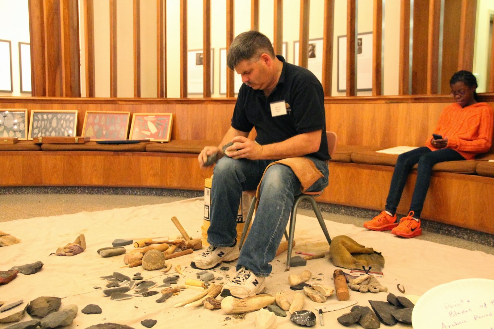
Steve Nissley, an expert flint knapper, set up a lithic tool
production workshop outside of the Auditorium. Steve’s demonstration is always
well received and much appreciated, as seen here by some of our younger
participants.


The morning began with opening remarks delivered by the
Director of the State Museum of Pennsylvania, David Dunn, followed by four PowerPoint
lectures focused on 18th century aspects of the workshop’s theme.

Wade Catts of John Milner & Associates relayed his
experience using a type of remote sensing technology called ground penetrating
radar, or GPR, to aid in the search for the remains of the Continental Powder
Works and gun factory at French Creek, Chester County. The complex had played
an active role in the American Revolution but was ultimately destroyed during
the conflict. Wade explained how East Pikeland Township has taken an active
role in preserving this unique piece of American history by securing a grant
from the American Battlefield Protection Program.


Janet Johnson, Curator in The State Museum of Pennsylvania’
Section of Archaeology spoke about the recent discovery, subsequent local and
state coordination, and ongoing conservation efforts to stabilize a Revolutionary War relic known as a Cheval de
Frise. A large number of these were placed in the Delaware River to thwart the
advances of the British Navy during its attack on Philadelphia. Once this
impressive 30 ft. long iron tipped “river spike” is preserved and exhibited, it
will serve as an effective vehicle to connect people with the events of the
American Revolution that took place in and around Philadelphia.

David Orr of Temple University discussed the work conducted work
at Valley Forage National Historic Park. He explained how archaeological
features recently discovered can transcend the well recited national historic
mythologies of hardship and endurance of the winter of 1777-1778. Isolated
trash pits, discrete cooking areas, and orderly arraignment of where the
soldiers’ huts once stood illustrated the less well known stories of
industriousness, effective leadership and disciplined training. These findings
are now contributing to a greater depth of understanding of this critical point
in the formation of our new nation.

Steve Warfel, retired Senior Curator of Archaeology at the
State Museum of Pennsylvania, presented details of Ephrata Cloister’s use as a
Revolutionary War hospital during 1777 – 1778. Through his extensive
excavations of now extant dormitory and prayer buildings on the National
Historic Landmark property, Steve has been able to tease apart military and
medicinal artifacts of the hospital period from those more domestic in nature
associated with religious community members. Thorough primary document research
combined with a long term archaeology program have created a more accurate
portrait of the past and corrected some secondary source romanticized histories
of the Cloister.
Following a break for lunch, the four lectures presented in
the afternoon continued with 19th Century aspects of the Workshop’s
theme.

Walter Rybka, Senior Captain of the Flagship Niagara, walked the audience through an
hour by hour timeline of the Battle of Lake Erie in 1813, a brief yet powerful
conflict on Pennsylvania’s Great Lake. He also outlined the history of a series
of reconstructions made of the war vessel, including his time and experiences as
Captain of the current ship. Today, the Niagara
is a high caliber combination living history museum and sailing ambassador of
the Commonwealth.

Mary Ann Levine of Franklin and Marshal College shared her
findings from excavations at the Thaddeus Stevens and Lydia Hamilton Smith
site, located in the historic district of Lancaster City, Pennsylvania. A curious
modification to a cistern coupled with oral histories and documentation of
Stevens as a prominent abolitionist suggest this site might have been a place
of refuge along the Underground Railroad. The nature of the function of such
sites makes their positive identification a rare occurrence.

John Roby of Indiana University of Pennsylvania offered his
listeners the notion of how a nuanced social context has the potential to lead
to a refined interpretation of archaeological remains. Ideas concerning social justice and
resistance through conscientious consumerism were introduced through the
example of the Free Sugar Movement of the mid – 19th Century. This
social lens was then applied to the archaeology of a multi-generational maple
sugar production farm owned by an African American family in Susquehanna County.

Ben Resnick from GAI Consultants discussed the accidental
discovery, analysis and re-burial with military honors of a civil war soldier
who had been killed during the first hours of the battle of Gettysburg. Using battle records he was able to lay out
the proceedings of the morning in the area known as the ‘railroad cut’, where
the remains had been found. Forensic
archaeology then made it possible to surmise a plausible end to this brave soldier’s
life. Current research
has narrowed the personal identification of this individual to one of about 30
candidates, and future research using DNA may be able to establish his
identity. As for now he has been
reburied with high honors as “Unknown Civil War Remains”.

Following the final
presentation, Judd Kratzer remarked on how each of the projects featured during
the program had contributed to our greater understanding of the conflicts
represented in the time period under discussion through archaeology field work
and analysis of material culture. There was also a brief question and answer
period to afford attendees the opportunity to pose specific comments or
questions to the presenters.The day’s events concluded with a casual wine and
cheese reception in the Archaeology gallery.

We would be remiss if we did not mention and thank our
dedicated group of volunteers who helped in all manner of ways, both in front
of and behind the scenes. We would not be able bring this event together without
your assistance. A special thanks to Judy Hawthorn who took pictures all day
long of the event.
Already looking ahead to next year, the Workshops in Archaeology program is
scheduled for Saturday November 8th, 2014. The theme will be the
Paleo-Indian time period and Ice Age peoples’ adaptations to a changing climate
and environment.
For more information, visit PAarchaeology.state.pa.us or the Hall of Anthropology and Archaeology at The State Museum of Pennsylvania .
Friday, November 15, 2013
Union County


This week in Pennsylvania Archaeology takes us to Union
County located near the heart of central Pennsylvania. In 1813 Union County was
formed from part of Northumberland County allowing for a living area of 317
square miles. The 2012 the census records reports a population of 45,000 people
living there and Lewisburg is the county seat.
Two physiographic sections make up Union County. The eastern
half is within the Susquehanna Lowlands while the western half is comprised of
the hills and ridges of the Appalachian Mountains. Elevations range from a low
of 938 feet in the valleys to a high of 1443 feet on the highest ridge tops. Both
Sections form a large part of the Ridge and Valley Province of central Pennsylvania
where the climate is temperate and largely pleasant year round.
The bedrock in Union County was formed from Ordovician,
Devonian and Silurian sediments (365-500 million years old). The bulk of the
county’s bedrock however, is made up of the 405-430 million year old Silurian
Period material. The remains of many fossilized plants and animal fauna have
been found in the strata of these rocks which are among some of the finest preserved
in the Commonwealth. The Faylor-Middle Creek Limestone Quarry at Winfield
contains some of the best calcite, fluorite and strontianite crystal specimens
that have been identified by Pennsylvania geologists (Geyer et al. 1976). Additionally,
there are massive chert bearing deposits in the Penns Creek drainage that were
exploited for stone tool material by different prehistoric Indian cultures (Bressler
1960).
The principal drainage of Union County is the Susquehanna’s
West Branch where its tributaries are east trending. Buffalo and Penns Creek
are the main secondary water sources. The former enters the West Branch at
Lewisburg and the latter continues on its southern course to enter Middle Creek
south of Selinsgrove, Pennsylvania.
Three Indian paths ran through Union County. The Great
Island Path skirted the northern part of the county and connected Great Island
at Lock Haven with Shamokin at the Forks of the Susquehanna at Sunbury. An
unnamed secondary path connected Great Island with the Penns Creek Path at
Millheim, Pennsylvania on Penns Creek. Along the southern border of Union
County ran the Penns Creek Path which also converged at the 18th
century Shamokin Indiantown once located at the Forks of the Susquehanna at
Sunbury.
A review of the Pennsylvania Archaeological Site Survey
(P.A.S.S.) files identified 142 recorded archaeological sites. Of these, 37 are
Historic and the remainder are Prehistoric. Most of the Historic sites are 19th
century in age, however, the reported prehistoric sites are representative of
all the recognized cultural periods in Pennsylvania, from Paleoindian through
the Late Woodland. In terms of site type, the majority are Late Woodland (25%)
and Late Archaic (22%) in that order of frequency. Transitional sites (16%) are
followed by Middle Archaic sites (14%) then Early Woodland at (7%). Next are
Middle Woodland (5%) and Paleoindian sites (5%) and ending with four Early
Archaic Period sites at (4%). Not unexpected, the primary choice of lithic
material for tool manufacture are local source cherts from the Keyser/Shriver
formations that occur in eroded outcrop and cobble locations in much of Union County. As well, open pit quarries
are reported from certain sections of the county.

The Bloomer Site (36Un82)

Excavation block profile (36Un82)
One of the principal cultural resource data recovery
projects in Union County was undertaken and completed in 1992 for U.S. Department
of Justice Federal Bureau of Prisons (Wall 1995). The project, located on a
Holocene/Pleistocene terrace on the West Branch Susquehanna River at Allenwood,
Pennsylvania, is a stratified prehistoric site. The site, designated in the
PASS files as 36Un82 is multi-component with Late Archaic, Transitional
(alternatively called Terminal Archaic by the investigators of the report), Early
Woodland and early Late Woodland (Clemson Island) period occupations.

Lamoka projectile points from the Bloomer Site (36Un82)
The deepest cultural level occurring at 36Un82 is 3Ab associated
with the Lamoka phase of the Late Archaic Period (Ritchie 1965; Funk 1993). Four hearth features from a living floor date
the Lamoka occupation(s) between 2950 BP and 3970 BP. The 2950 B.P. radiocarbon date seems too late
in time for this occupation, therefore the remaining cluster of four dates which
averaged out at 3820 B.P. indicate an approximate site occupation by Lamoka phase
people around 3800 B.P.

Broadspears from the Bloomer Site (36Un82)
The Transitional Period Broadspear phase occupation(s) was
identified immediately above the Lamoka levels of 2Bwb and occasionally
co-mingled with younger Early Woodland Period Fishtail and Meadowwood phase points
that had apparently made their way into the deeper Broadspear phase level from the
Bwb. Three radiocarbon dates from hearth contexts suggest an occupation(s) range
for this component between 2900 BP and 3640 B.P., but again, by eliminating the
youngest of the three dates (the 2900 date) which appears to be an outlier, an
averaged date of the actual Broadspear occupation would have been around 3610
B.P.

Fishtail projectile points from 36Un82

Triangle projectile points from 36Un82
It is unfortunate that there were no radiocarbon dates linking
the site’s cultural chronology in the next upper level designated as 2Ab. This
was the site’s uppermost intact level containing the Fishtail phase and
Meadowood phase points. However, the outlier date noted for the Late Archaic
date cluster seems closer to the Early Woodland and may in fact date that
occupation at 36Un82. Typically, these occupations at other Susquehanna Valley
sites date between 2500 B.P. and 2200 B.P. - not that far temporally removed
from the aforementioned 2900 B.P. date.

Plan view of Clemsons Island house structure
The uppermost deposit at 36Un82 designated as Bwb contained
pit and postmold features representative of the Late Woodland Clemson Island
phase. This and its Early Owasco counterpart are the dominant cultural
expressions thus far recognized for the entire West Branch valley (Turnbaugh
1977). Features of the Clemson Island phase were prolific at site 36Un82 and
largely consisted of hearths, refuse and storage pits containing cultural
debris such as decorated grit tempered pottery, broad based triangular points
and numerous cobble tools commonly associated with lithic reduction and food
preparation activities. The majority of these features are likely linked to the
remains of an adjacent longhouse. Associated radiocarbon dates place the
occupation between 970 and 1070 B.P. The assumed date of occupation is the
average of the two dates or 1020 B.P.
We hope that you have enjoyed this brief introduction to the
archaeology of Union County and we encourage you to consult the Reference Section of this TWIPA submission for further information on
Pennsylvania history and archaeology of the cultures that once lived here.
Mark your caledar!
The State Museum of Pennsylvania's
Section of Archaeology will be hosting its Annual Workshops in Archaeology on
Saturday November 16, 2013. This year's theme is the Archaeology of a
Troubled Nation, 1775-1865. As always, lectures will be presented by
professionals from throughout the region as well as artifact identification in
the afternoon, so don't forget your "what's this". This year will also
include John Heckman, a Civil War reenactor who will showcase the uniform and
equipment of a common Pennsylvania soldier during the American Civil War. A
reception in the Hall of Anthropology and Archaeology will conclude the event.
Click
here to see the brochure which includes all the details.
References
Bressler, James P.
1960 The Penns Creek Archaic Workshops. Pennsylvania
Archaeologist 30(1):25-29.
Funk, Robert E.
1993 Archaeological Investigations in the
Upper Susquehanna Valley, New York State. Two volumes. Persimmon Press
Monographs in Archaeology.
Geyer, Alan R., Robert C. Smith
and John H. Barnes
1978 Mineral Collecting In Pennsylvania.
Department of Environmental Resources Topographic and Geologic Survey.
Harrisburg.
Ritchie,
William A.
1965 The Archaeology of New York State.
The Natural History Press, Garden City, New York.
Turnbaugh,
William A.
1977 Man, Land and Time: The Cultural
Prehistory and Demographic Patterns of North-Central Pennsylvania.
Unigraphic Press, Evansville, Illinois.
Wall,
Robert D.
1995 Phase III Archaeological
Investigations 36UN82 Union County, Pennsylvania. ER#89-1630-119. Allenwood
Pennsylvania Federal Correctional Complex Sanitary Water treatment Facility. Louis
Berger & Associates, Inc. Report prepared for the U.S.Department of Justice,
Federal Bureau of Prisons. Washington D.C.
Wallace, Paul A.W.
1965 Indian Paths of Pennsylvania. Pennsylvania Historical
and Museum Commission. Harrisburg.
For more information, visit PAarchaeology.state.pa.us or the Hall of Anthropology and Archaeology at The State Museum of Pennsylvania .
Subscribe to:
Posts (Atom)