 |
| Northumberland County is Nb on the above map |
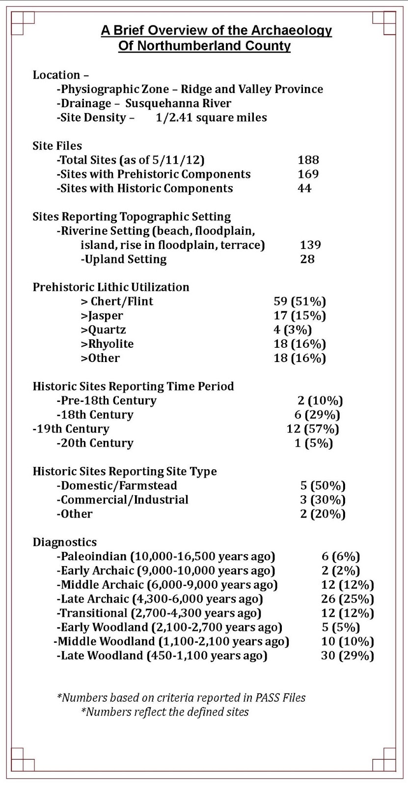
Our journey through the archaeological heritage of Pennsylvania takes us
to the central region of the state, Northumberland County. Located in the Ridge
and Valley Physiographic Province the terrain is composed of long linear
mountainous ridges and rich, fertile valleys in between these ridges. The Susquehanna River has cut a wider valley
in the sandstone and shale bedrock which underlies much of the region. Lithic
resources used by Native Americans include two chert formations, the
Onondaga/Old Port formation and the Keyser formation. Stone tools are also
frequently found in a fine grained, slightly metamorphosed material of unknown
origin. The chert formations provided native peoples with brownish black to
gray cherts for their stone tools.
 |
| View of the Susquehanna River Valley at Sunbury |
The location of this county on the
Susquehanna River provided an opportunity to travel and trade for cherts from
the surrounding areas as evidenced in archaeological materials recovered. The
greatest percentages of sites recorded in the Pennsylvania Archaeological Site
Survey files (PASS) are located in riverine settings; many of them are located
along the Susquehanna. Indian foot paths which transected the area include the
Tulpehocken Path, Penns Creek Path, Shamokin Path and the Wyalusing Path with
additional secondary paths. These paths
ran along the mountain ridges and valleys that form the topography of this
county.
It is difficult today to imagine
that Northumberland County was considered a frontier area
virtually unsettled until the 18th century. Established in 1772 as
the tenth county organized in Pennsylvania it was created from an 8,000 square
mile tract of land lying northwest of the counties of Lancaster, Cumberland,
Berks, Northampton, and Bedford. The land area of Northumberland County
eventually increased to 15,000 square miles, covering the Susquehanna Valley,
including all the land west of the Lehigh River to the Allegheny River and all
of the land south of the New York State border to Juniata County. As the area
grew and became more populated, the county was divided multiple times, which
eventually led to the establishment of twenty-nine counties from this original
15,000 square mile tract of land.
The PASS files list sites in all of
the occupation time periods for this county and include six Paleoindian Period
(10,000-16,500 years ago) sites. One of these sites was surfaced collected by
locals for many years prior to a formal excavation for a Pennsylvania
Department of Transportation bridge replacement project. An archaeological investigation conducted for
the Allenwood Bridge Replacement project in the late 1980’s uncovered
archaeological features from the Late Archaic/Transitional Period through the
Late Woodland Period. Evidence of the
Late Archaic occupation included thirty-seven stemmed and side-notched
points. Three burn features were identified and
radiocarbon dated to between 2007 – 3367 years ago. These would place the
occupations in the Transitional and Early Woodland periods. Archaeologists determined that the site was
likely occupied for short periods, possibly in the fall as indicated by
nutshell recovered in one of the features.
 |
| Structure 1 at 36Nb3, note the charred post at far left of image |
The later occupation dates for this
site were determined based on both radiocarbon dating and the recovery of
associated prehistoric ceramics. Soil features included semi-circular post mold
patterns interpreted as Clemson Island (circa 1000 AD) house patterns. An additional Late Woodland occupation was
identified as Shenks Ferry based on ceramics recovered in a burn feature with a
radiocarbon date of 1494±90 B.P. Two semi-subterranean keyhole structures were
also identified and firmly dated to the Shenks Ferry culture time period (1400-1500
AD). These keyhole structures are
frequently found on the periphery of Late Woodland villages (Hatch1980), and it
was surmised that these structures also represent the western periphery of a
series of Late Woodland villages at 36Nb3.
Agricultural remains recovered include maize, beans, grape seed and
nutshell. The excavation provided a wealth of information for Late Woodland
occupations that furthered our understanding of these culture groups and led
the way for additional specialized analysis of archaeological investigations.
 |
| 36Nb117 surface collecting of site |
Excavations conducted by the
Pennsylvania Historical & Museum Commission (PHMC) in the 1990’s uncovered
additional evidence of another Late Archaic site. The Central Builders site
(36Nb117) is located two miles from the confluence of the north and west
branches of the Susquehanna River. It was the location of the first Archaeology
Week celebration in Pennsylvania in 1990.
It attracted local attention because it contained a high concentration
of artifacts on the site’s surface. The initial work consisted of a controlled
surface collection and this produced thousands of artifacts dating from Early
Archaic to Late Woodland times. During this process, a large Late Archaic
fire-cracked-rock feature was located and partially excavated. The most
significant data however, was uncovered during geomorphological testing. A
short backhoe trench was placed on the levee in order to examine site
stratigraphy of the soil. Near the bottom, at a depth of approximately nine
feet, a few artifacts were uncovered including two large chert cores. Over the
next several months, a two meter square was placed and excavated to the depth
of the artifacts. At the level of the two cores, more artifacts were uncovered
along with a metarhyolite Kirk corner notched projectile point and a small
hearth. The charcoal from this hearth was radiometrically dated to 9165+210/-205
BP. The metarhyolite was carried 130
kilometers (80.7 miles) from its source in South Mountain near Gettysburg and
demonstrates that Early Archaic bands were moving over and occupying large
territories.
 |
| Metarhyolite Kirk point recovered from Central Builder's site. |
Northumberland County played an
important role during the French & Indian War (1755-1763). Fort Augusta
(36Nb71), located at present day Sunbury, was the largest defensive fort
established on the Susquehanna River. This was considered the western frontier
at that time. Construction began in 1756
and improvements continued until 1758. It was the garrisoned the longest by
provincial troops and provided Indian trade to the nearby village of Shamokin.
After 1761 Augusta was the only provincial fort maintained in the commonwealth
(Waddell & Bomberger 1996).
Excavations conducted here under the Works Progress Administration (WPA)
uncovered portions of the stockade and personal effects that provided evidence
of foods and daily activities of the troops.
 |
| 1756 map of Pennsylvania note the location of Shamokin |
The Commonwealth of Pennsylvania Fort Augusta
 |
| WPA excavation in 1938 was visited by a group of boy scouts |
 |
| Field drawing of the excavation of the Powder Magazine at 36Nb71 |
 |
| Excavation of the Powder Magazine |
We would be remiss in not
reporting on another of our PHMC properties in Northumberland County, the
Joseph Priestley House. Joseph Priestley
is most notable for his discovery in 1774 of oxygen while living in England. Very few people know that he relocated to
Pennsylvania after his home and labs were burned because of his religious
beliefs. Priestley’s support of the American Revolution and his opposition to
the Angelican Church combined with support of the French Revolution led
anti-French rioters to destroy his home burning his lab and extensive library
in 1791. Priestley relocated in 1794 and
died here in 1804. He was a noted theologian, political progressive and
prolific author whose scientific contributions include the development of the
carbonation process, the identification of carbon monoxide, and early
experiments with electricity.
 |
| Concentration of lab equipment recovered at Joseph Priestley House (36Nb70) |
Excavations conducted by
the PHMC under the direction of Stephen G. Warfel at (36Nb70) recovered
evidence of Priestley’s lab equipment. Archaeologists discovered the most important
artifact assemblage recovered during the 1986 field season – 259 fragments of
broken laboratory equipment. The fragments primarily consisted of earthenware
tubes, some of which retained chemical residues. Analysis of a sample of these tube
fragments and residues permitted speculative reconstruction of experiments Dr.
Priestley had performed in his laboratory.“Characterization of the residues ...
suggested that in all cases the labware was utilized at elevated temperatures
and most likely in the presence of molten reactants” (Scheetz and Smith 1990). Experiments were
clearly designed to produce oxygen, a finding consistent with Dr. Priestley’s
efforts to defend his theory of phlogiston during the final years of his life
(see Soloveichik 1962: 644-646.) The discovery of laboratory apparatus
fragments in Test Pit 1, located in close proximity to the door and window of
Dr. Priestley’s laboratory, is no coincidence. They were obviously discarded
after breakage by being tossed through one or the other opening, a refuse
disposal practice consistent with 18th century behavior. (Warfel 1997) The
recovery of these laboratory artifacts and household goods provide tangible
evidence of this important researcher and theologian. Visitors to the site can
enjoy the house and reconstructed laboratory, furnishings include the fragments
of his laboratory equipment and household furnishings.
 |
| Fragments of household wares recovered from site excavations at 36Nb70 |
We hope you have
enjoyed this journey through the rich archaeological heritage of Northumberland
County and you will seek out the heritage of your community. Understanding and exploring our
archaeological heritage is pivotal to our understanding of human behavior and
our ability to change and adapt over time- just as the peoples of
Northumberland County have done for thousands of years.
Wallace, Paul A.W.
1965 Indian Paths of Pennsylvania. The Pennsylvania Historical and Museum Commission. Harrisburg
Warfel, Stephen G.
1997 ARCHAEOLOGICAL INVESTIGATIONS AT THE JOSEPH PRIESTLEY HOUSE AND LABORATORY, 36 Nb 70, 1986 and 1992.
For more information, visit PAarchaeology.state.pa.us or the Hall of Anthropology and Archaeology at The State Museum of Pennsylvania .
No comments:
Post a Comment