

This Week In
Pennsylvania Archaeology takes us to Susquehanna County located in the hilly
region of northern Pennsylvania. Susquehanna County was established in 1810
from lands claimed by Luzerne. Named after the Susquehanna River, it has a total
area of 832 square miles and it is this drainage that winds its way south, where
it eventually drains to Chesapeake Bay at Port Deposit, Maryland. Secondary
drainages flow to the north and south and include Tunkhannock, Meshoppen,
Wyalusing, along with many of the Susquehanna’s smaller tributaries. They join
the main North Branch channel at different locations in the county.
Susquehanna County
is within the Glaciated Plateau Section of the Appalachian Plateaus Province.
The physical landforms are characterized by gentle to moderately rolling hilly
uplands, ridges with narrow valleys typical for the general configuration of
the Glaciated Plateau in east-central Pennsylvania. Geologically,
Susquehanna County is made up of sandstone and shale deposits of the Devonian period
(365 – 405 million years old). Fossilized animal remains include brachiopods and
crinoids from long ago. The ridges all around the county
are capped with weather resistant sandstone and softer rocks such as siltstone
and shale. During the
Pleistocene period Susquehanna County was covered by a series of thick ice
mantles. Along the main and secondary valleys are the residual sediments from glacial
activity consisting of glacial cobbles, sand and pebble deposits. These residual deposits, which are
quite abundant in the county, have been mapped by the Pennsylvania Geological
Survey and have been commercially mined for road base material.
The only Indian
path that ran through Susquehanna County was the “Lackawanna Path”. Prior to,
during, and after the 18th century, this path joined with others to
form an elaborate complex of trails connecting different parts of the
Pennsylvania landscape (Wallace 1971). Although there are no reported Indian
towns along these routes, they connected Indian towns at each end, namely
Lackawanna and Capoose Meadows near Scranton to Tuscarora Town at present day
Lanesboro on the the Great Bend of the Susquehanna, near the New York State
border. Of note here, is the observation that a segment of Interstate 81
follows the general route of this ancient Indian path between these two
locations.

view of the bridge replacement project area at
Hallstead, Susquehanna County
A review of
the Pennsylvania Archaeological Site Survey (P.A.S.S.) identifies 143
prehistoric and historic period sites in Susquehanna County, which accounts for a
site density of one site for every 5.83 square miles. The majority of these
sites fall into one or more of the seven prehistoric periods, with the Transitional
accounting for most. Trending in highest site frequency to least, Transitional Period sites are followed
by Late Woodland, Late Archaic, and Middle Woodland Period sites. Middle and
Early Archaic sites are rare. In terms of site setting, the most recorded are situated along valley floors adjacent to large perennial water
sources such as rivers and second order streams. Thirty three of the
prehistoric sites occupy upland settings where the water systems
are smaller, often consisting of low volume seeps and springs. Lithics used in
the manufacture of projectile points and cutting tools are principally made
from cobble cherts, granites and indurated sandstone/siltstones from the eroded glacial deposits within the valley. Reported
Historic Period sites are largely comprised of rural farmsteads, house sites, remnants
of related out building structures and bridges.

plan view of features within upper levels of the Keystone Farm Site (36Sq17)
In 1999 the Federal
Highway Administration/PennDot and archaeological consultants conducted a
geo-archaeological and Phase I/II and III archaeological study at Hallstead,
Susquehanna County. This investigation was in preparation for a proposed bridge
relocation on the “Great Bend” of the Susquehanna River. These investigations
identified a deeply stratified multi-component site containing prehistoric
occupations with various projectile points, scrapers, utilized flakes, pottery
and fire cracked rock. Many of these objects date from the Middle Archaic
Period through the Late Woodland Period. The Pennsylvania Archaeological Site
Survey file lists the site as 36SQ17.
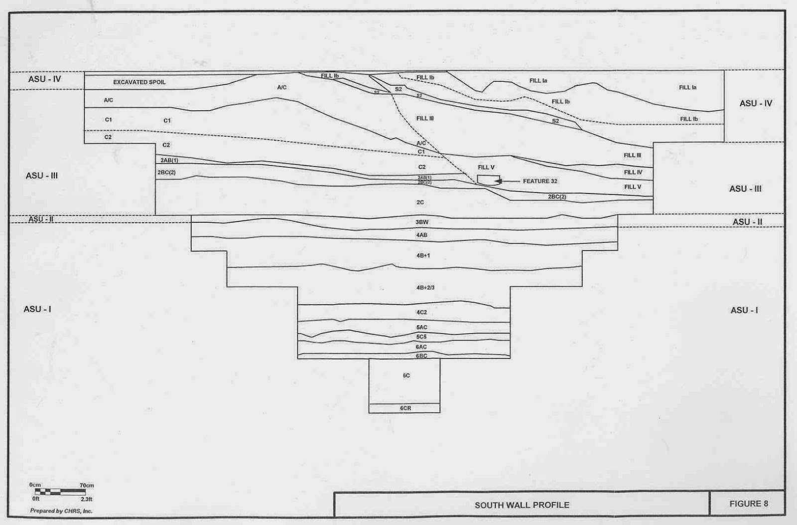
profile of excavation block at the Keystone Farm Site (36Sq17)
Some of the
pit and post mold features in the upper strata at 36SQ17 containing fragments of Owasco
pottery and triangular projectile points were radiocarbon dated between 1060
BP. and 940 BP, which suggests a site occupation around 1000 B.P. Preserved
botanical remains included wood charcoal, nut shells, seeds and other
unidentified (as to Genus and species) carbonized plant parts. Additionally,
at the 2.63 meter depth and slightly deeper, two radiocarbon dates spanned a
time between 4780 B.P. and 7630 B.P. Both dates fall within the range defining
the Late Archaic and Middle Archaic Periods in the Northeast. There Vestal, and
Brewerton points were recovered.

line drawings of projectile points recovered from the Keystone Farm Site (36Sq17)
The older date may relate to a Neville phase
occupation although that has not been confirmed with diagnostic artifacts. The
deepest cultural level identified at the Keystone Farm Site, (36Sq17), was found at
four meters below ground surface. Discovered within the sandy alluvium stratum, designated
as “6BC,” were segments of a living floor that had been utilized by
LeCroy phase people, around 8000 BP. In this deepest level at 36SQ17 one
diagnostic biface, a Titicut point (LeCroy variant), was recovered with chert
debitage and utilized flakes. Further analysis determined that the pattern of
these artifacts suggests some sort of lithic workshop activity, possibly
focused on late stage tool production or re-sharpening.

density map of debitage and tools from stratum "6BC" at the Keystone Farm Site (36Sq17)
We hope you have enjoyed this brief
introduction to Susquehanna County archaeology. Also, we encourage you to consider joining us at our annual Workshops in Archaeology program on November 16th to
learn more about the archaeological heritage of Susquehanna
County. Dr. John Roby of Indiana University of Pennsylvania' s Department of Anthropology will present The Dennis Farm: Maple Sugar, Production and
Politics in the 19th Century. This homestead has continuously
belonged to the original African-American landowners’ family for over 200 years.
Purchased with monies received for service during the Revolutionary War,
preservation of this family homestead provides a unique opportunity to examine
property held continuously by one family over multiple generations. The link for the registration form for the Workshops is
in the upper right corner of this blog page; please remember the deadline for
early registration is November 8th!
References:
Cultural Heritage Research Services,
Inc.
2008 Archaeological
Investigations S.R. 0011, Section 573, Great Bend Bridge Project, Susquehanna
County, Pennsylvania. E.R.# 00-6202-115. Report prepared for U.S. Department of
Transportation - manuscript of file at the Section of Archaeology, The State Museum of Pennsylvania
Wallace, Paul A. W.
1971 Indian
Paths of Pennsylvania. Publication of the Pennsylvania Historical and
Museum Commission.For more information, visit PAarchaeology.state.pa.us or the Hall of Anthropology and Archaeology at The State Museum of Pennsylvania .
No comments:
Post a Comment