This past weekend marked the 88th
annual meeting of the Society for Pennsylvania Archaeology. Individuals from The
State Museum of Pennsylvania presented on a variety of topics ranging from
using LiDAR to document archaeological and historic sites; attribute analysis
of 18th century ceramics; examination of a contact period collection and an
analysis of Washington Boro face effigy pottery.
This got me thinking - what is it
about south central and eastern Pennsylvania that has drawn people here for
thousands of years, a trend that is especially visible since the arrival of
Europeans to the area. The answer lies in the geography of the region. Harrisburg
is situated at the crossroads of the Susquehanna River and the Great Valley, which
have been major trade routes since prehistoric times. This region of
Pennsylvania is also situated just west of the fall line, which divides the Piedmont
physiographic province from the Atlantic coastal plain. These geologic features
have affected human settlement patterns throughout the past, and they continue
to do so today.
The geologic feature known as the fall
line acts as a natural barrier between the coastal plain and the regions to the
west; It is most visible in rivers where waterfalls mark the location of this
geographic feature throughout states along the East Coast. At these locations,
fish migrating upstream to spawn are slowed and easily trapped in nets. The
falls at Trenton on the Delaware and at Conowingo on the Susquehanna during the
Late Archaic through Early Woodland periods were heavily occupied by Indians
exploiting this resource. In addition, at the fall line, prehistoric
settlements and historic cities would have served as a transitional point for
goods being transported inland. The Great Valley Section of the Ridge and
Valley Province has been an important north-south trade and migration route
since before the arrival of Europeans.
The division between the Coastal Plain and
Piedmont physiographic sections and an illustrated cross section of the fall
line.
Source: (top) The National Atlas of the
United States, (above) Encyclopedia Britannica
The Great Valley
Contact Period Settlements in
Southeastern Pennsylvania
The Susquehanna River provides a passage to the west from settlements on
the East Coast through the Appalachian Mountains. The Late Woodland (1550
AD-1000 BP) and Contact period sites (1780 AD – 1550 AD) located on the Lower Susquehanna
River acted as a hub for trade between European settlements on the coastal
plain, and regions controlled by native populations further inland. The
Susquehannocks, a contact period tribe, used their strategic location in the
Lower Susquehanna Valley (in the area between what is now called Harrisburg and
Safe Harbor, PA) to control the fur trade in the region. The Iroquois
Confederacy, who were competing with the Susquehannocks for the fur trade,
realized the strategic significance of this location and in the 1670’s attacked
and eliminated the Susquehannocks from the trade.
Indian paths of Pennsylvania overlaid on a
digital shaded relief map of Pennsylvania
Source: Paul Wallace, Indian Paths of Pennsylvania overlaid on DCNR digital shaded relief
map
The Effects of Geography on Modern
Settlements
Many of the East Coast’s largest cities (historic and modern) are located
along the fall line, including Philadelphia, Baltimore, New York City and
Washington D.C. to name a few–It’s no coincidence that these locations were
used by prehistoric people prior to the arrival of Europeans. Most of the
cities mentioned above still serve as ports. Baltimore and Philadelphia both
played major roles on settlements in the Lower Susquehanna Valley.
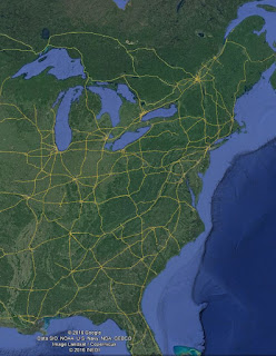
Harrisburg which, as previously mentioned, is located at the crossroads of the Great Valley and the Susquehanna River still sits at a strategic location for the transportation of goods throughout the region. The path that existed in prehistoric times through the Great Valley followed a route that is very similar to the modern corridor for Interstate 81. There are many other considerations that have factored into human settlement patterns in the Lower Susquehanna Valley, but the area has proven to be a strategic trade location abundant with natural resources.
Prehistoric trade routes and modern
interstates show the role that geography plays in navigation.
Source: (top) Encyclopedia of North
American Indians, (above) Google Earth
Conclusion
A basic understanding of the natural forces that shape where we live adds
context and helps us to understand the ways in which human habitation has been
shaped by our natural environment throughout time. Archaeologists examine these
landscapes to better understand settlement patterns of the past and predict
future settlement patterns. Although
much has changed since Europeans landed on this continent, the geography remains
much the same. As a result, modern populations are still being shaped by their
surrounding landscape.
We hope you have enjoyed this discussion
of our rich Pennsylvania landscape and the impact of land formation on
settlement patterns. We invite you to
consider the geography of your community and consider its natural
resources. This is your heritage and
embracing the cultural and environmental resources of our earth are an
important part of Preserving the Past for
the Future.
References
Jennings, F. (1966). The Indian Trade of the
Susquehanna Valley. Proceedings
of the American Philosophical Society, 110(6),
406-424. Retrieved from http://www.jstor.org/stable/985794
Kent, B. C. (1984). Susquehanna's Indians (No. 6). Pennsylvania Historical &
Museum Commission
Merritt, J. T. (2011). At the Crossroads: Indians and
Empires on a Mid-Atlantic Frontier, 1700-1763. UNC Press Books.
Wallace, P. A. (1993). Indian Paths of Pennsylvania. Commonwealth
of Pennsylvania, Pennsylvania Historical & Museum Commission.


No comments:
Post a Comment