Friday, April 26, 2013

Kinsey Scholarship, J. Alden Mason Award and Volunteer Recognition Program


This week in our travels through Pennsylvania, we are going to take time out to congratulate some special people who have made a difference in Pennsylvania archaeology.

First, the W. Fred Kinsey Scholarship was awarded this year to senior Morgan Rouscher of Gettysburg College.  Morgan presented her paper “Working Together: Exploring the Use of Public Archaeology in Waynesboro, PA” at the 84th annual meeting of the Society for Pennsylvania Archaeology in Uniontown.  Award of this scholarship provides students with recognition of their research endeavors and encourages participation in a forum that focuses on Pennsylvania archaeology. Papers selected for this award are subsequently edited and reviewed for publication in the journal Pennsylvania Archaeologist. The first scholarship recipient, Jonathan R. Libbon, was published in the Fall 2012 issue of the journal and last year’s recipient, Jennifer Rankin is scheduled for publication later this year.

Ms. Roucher accepting the W. Fred Kinsey Scholarship Award at the 84th Annual Society for Pennsylvania Archaeology meeting

The W. Fred Kinsey Scholarship program began in 2011 in an effort to promote student participation at the annual meetings of the Society. Dr. Kinsey was a curator with the Pennsylvania Historical and Museum Commission (PHMC) in the late 1950 and early 1960s. This was followed by twenty five years at Franklin and Marshall College and The North Museum in Lancaster County. His work on the prehistory of the Upper Delaware river valley laid the foundation for much of the interpretation of this region of Pennsylvania. In addition to his contributions to archaeological investigations, he mentored many students who went on to become significant archaeologists on their own merits.

Morgan’s paper focused on an eighteenth century rural farmstead site which was occupied by one German Baptists family, the Stoner’s, from 1740 to 1850.  Assistance with this excavation was provided by members of Cumberland Valley Chapter #27 of the Society for Pennsylvania Archaeology.  This site provides an opportunity to document the daily activities of a working farm through the archaeological evidence recovered during excavations. Farmstead sites typically provide an opportunity to examine agricultural practices- where areas were fenced, barn construction methods and size, number and location of outbuildings, and general land use patterns.  Artifacts recovered during this investigation will be analyzed for indicators of consumerism- local or imported, duration for which the product was used and conditions under which it was discarded. These questions provide archaeologists a chance to compare a working farm, occupied by German Baptists in this case, with farms operated by other ethnic groups who settled in Pennsylvania.  This site type is also a perfect connection for the local community to connect to their past in ways that more renowned sites might not. Morgan selected this site’s public involvement as a chance to educate the local community as to the value of archaeology to them and everyone’s understanding of the past.
We wish to congratulate Morgan on her accomplishment and hope to assist her with development of her paper for publication.
 
Our second award winner is Janet Johnson, Curator, The State Museum of Pennsylvania. Janet received the highest honor conferred on a professional archaeologist by the Society for Pennsylvania Archaeology, the J. Alden Mason Award. The following was read for her award.

Janet Johnson accepting the J. Alden Mason award at the 84th Annual Society for Pennsylvania Archaeology meeting


This award is in honor of John Alden Mason.  He was a noted North and South American Archaeologist, a professor at the University of Pennsylvania, and a founding member of Society for Pennsylvania Archaeology, Inc. (SPA). This award is presented to a professional archaeologist or a professional in a related science and is based upon his/her contribution to education and encouragement of SPA members in the proper pursuit of archaeology.

The Archaeology Section of the State Museum of Pennsylvania houses over 4.5 million artifacts.  When need to do some research, or to examine artifacts, or to ask questions; we turn to the person who is always there when we need her. She works long hours facilitating the care of material remains of historic and prehistoric peoples who called Pennsylvania their home.  In her trust is our precious Pennsylvania history.  She is a tireless supporter of archaeology and goes the extra mile to make archaeology accessible to SPA members, students, researchers and the general public.
 
Janet Johnson began as an intern at the State Museum of Pennsylvania in 1979 and joined the staff in 1993. In 2004 she was promoted to curator.  Curator, Janet Johnson encourages the use of the museum’s collections for education and research, and in spite of her busy work schedule she makes herself available to aide persons doing research. She is especially good with young researchers and mentors high school and college students.  Janet understands that Pennsylvania archaeology cannot grow without encouraging students.

Janet is in charge of volunteers at the museum, is on the SPA C14 committee and helped establish the Kinsey scholarship.  She has participated at various excavations in Pennsylvania, including Fort Hunter.  Janet works closely each year with the archaeology exhibits at the Pennsylvania Farm Show, which is a major event that encourages interest in Pennsylvania archaeology. Janet published with McConaughy in 2003 - Sugar Run Mound and Village and with Kent, Rice, and Ota in  1981 -  A map of 18th Century Indian towns in Pennsylvania.

Her most recent research has focused on New Deal historical archaeology in Pennsylvania.  Janet, is also working with the Virtual Curation Laboratory at Virginia Commonwealth University, regarding Susquehannock animal and human effigies on vessels and smoking pipes.
For her many contributions to archaeology and dedication to the principles of the Society for Pennsylvania Archaeology, Janet Johnson is presented with the J. Alden Mason  Award.

Finally, this Saturday April 27th, the Pennsylvania Historical and Museum Commission will hold its annual volunteer recognition program at The State Museum of Pennsylvania in Harrisburg. Each spring the Commission celebrates the many volunteers who contribute their time, expertise and hard work to making the historic sites and museums of the PHMC premier attractions around the Commonwealth. TWIPA would like to take this opportunity to thank the individuals who make up a small army of volunteers that regularly dedicate a portion of their time with the Section of Archaeology at the State Museum of PA. Much of what we do wouldn’t happen without their help. We tip out hats to Andi, Laina, Toni, Sheila, Sid, Amber, Andy, Clydene, Merikay, Elijah, Tessa, Krissy, Cassie, and everyone else we may have overlooked, you guys are the best.  THANK YOU!


For more information, visit PAarchaeology.state.pa.us or the Hall of Anthropology and Archaeology at The State Museum of Pennsylvania .

Thursday, April 18, 2013

Society for Pennsylvania Archaeology 84th Annual Meeting


We're taking a break this week from our county by county posts to remind everyone that the Society for Pennsylvania Archaeology's 84th annual meeting is taking place this weekend, April 19-21, at the Holiday Inn, in beautiful Uniontown, Pennsylvania. Promising enjoyable and informative presentations spread out over three sessions, this year's meeting is being sponsored by the Mon-Yough Chapter (#3) of the Society.

A student poster session is being sponsored and will run concurrently in the bookroom, which will also offer obscure and hard- to-find books and journals on regional archaeology for purchase.  

Saturday night’s banquet features a lecture by Dr. David Orr, Professor of Anthropology, Department of Anthropology at Temple University. Dr. Orr’s presentation is entitled, City Point Virginia: Before the Civil War, during the War and Today

In addition, numerous awards will be presented for a variety of achievements in the field of Pennsylvania archaeology including; lifetime achievement, outstanding avocational archaeologist, most sites recorded in the past year and more. Finally, the evening’s formal events will conclude with the celebrated and spirited auction, with proceeds benefiting the Society.

The Society for Pennsylvania Archaeology was formed in 1929 by the Pennsylvania Historical Commission to promote the study of prehistoric and historic archaeological resources of Pennsylvania and neighboring states; to encourage scientific research. Avocational and professional archaeologists come together to learn about current research and preservation of archaeological sites and artifacts. Stop by the Society's website for more information.

Please join us for an educational and entertaining weekend in Uniontown. We hope to see you at the meeting!

For more information, visit PAarchaeology.state.pa.us or the Hall of Anthropology and Archaeology at The State Museum of Pennsylvania .

Friday, April 12, 2013

Montour County- Our Smallest County


Montour County is abbreviated "Mo" on this map

This week our journey by county tour through the archaeology of Pennsylvania takes us to central Pennsylvania and Montour County. This county is situated in the Susquehanna Lowland section of the Ridge and Valley physiographic Province.  The Chillisquaque Creek is the major drainage and it flows to the west, joining the West Branch of the Susquehanna River in Northumberland County. Mahoning Creek drains the southern portion of the county into the North Branch of the Susquehanna River at Danville. Montour Ridge covers the southern 20% of the county and the remainder is a lowland area drained by the Chillisquaque Creek.

The site density is above average at 1 site per 1.51 square miles.  However, sites are not evenly distributed across the landscape. Approximately 88% are located along a 3.5 mile stretch of the Chillisquaque as it flows through this central lowland area. The lowland area probably contained numerous plant and animal resources and would have been highly desirable to the prehistoric inhabitants. In addition, reportedly, there are chert outcrops just east of this region that would represent an additional attraction for Native peoples. About 10% of the sites in Montour County produced pottery and all of these are along the same stretch of the Chillisquaque suggesting that the use of this area included at least temporary habitation sites and were not simply transient foraging camps.


chert (left) and metarhyolite (right) projectile points from Montour County

Only ten sites have been recorded along the main stem of the Susquehanna River where a higher density would be expected. The likely reason for this disparity is reporter bias. The majority of the sites along the Chillisquaque were recorded by one individual and therefore this is not representative of the entire county.
The most common lithic resource for the production of prehistoric stone tools is chert. Relatively small outcrops of this material are present throughout the Ridge and Valley province. As mentioned above, at least one outcrop is believed to be located in the county. Interestingly, metarhyolite and jasper are the next two most common lithic types and these outcrops are far away at a distance of 125 miles and 100 miles respectively. During the Transitional period (4300 – 2700 years ago) these materials were commonly traded throughout the Middle Atlantic region and their presence may be the result of this type of cultural activity rather than the direct procurement of this material.

The largest archaeological survey conducted in the county was performed in preparation for the Limestone Handling Area and pipeline associated with the PPL’s Montour Steam Electric Station near Washingtonville. This project is situated near the Chillisquaque Creek, within the lowland section of the county. The soils in this area are residual or thin alluvial deposits and stratified Holocene soils are a low probability for archaeological sites. A Phase I survey identified five sites; 36Mo80, 36Mo82, 36Mo83, 36Mo84 and 36Mo85. Two sites, 36Mo80 and 36Mo83, were considered potentially eligible for the National Register and required an additional Phase II investigation to determine their eligibility to the National Register.


The Strawberry Ridge site (36Mo80) was tested using a controlled surface collection and a number of excavation units. This produced few artifacts (n=227) over an approximately four acre area with a concentration at the north end of the site. The debitage (flakes) suggested an activity area where the final stages of stone tool manufacture took place and/or tool refurbishing ((re-sharpening). All of the lithic material was the local Shriver chert. The site also produced a blocky chert that was rarely worked. It is not known if this material originates in the Shriver formation or actually came from some un-identified source. The author of the report (Kira Presler – now Kira Heinrich of the Bureau for Historic Preservation), hypothesized that the site represented repeated short term visits to the area in order to exploit biological resources (food or raw materials such as reeds for basketry) in the adjacent wetland. On most occasions, the visits were believed to have been short term, involving very small numbers of individuals. The northern activity area represents a more substantial camp where the resources were processed with cutting and scraping tools. This may represent the activities of a small work group or family who visited the site for a day or two. Based on diagnostic projectile points, the site was used between Middle Archaic and Middle Woodland times (9000 – 1100 years ago).


chert projectile points from 36Mo83

The Beaver Run site (36Mo83) produced 251 prehistoric artifacts. As with Strawberry Ridge, the majority of these artifacts were made from Shriver chert but a few jasper and metarhyolite pieces were also recovered. This site did not produce any concentrations of artifacts, tool types or debitage. Analysis indicates that this site was repeatedly used for brief periods of time for resource procurement activities. The only projectile points recovered were two broadspears, one in jasper and the other from metarhyolite. The jasper piece appears to be of the Perkiomen point type. This may represent a single component site but more than likely the occupations cover multiple time periods. The activities at this site also seem to focus on the exploitation of the adjacent wet land.

jasper Perkiomen style projectile point from 36Mo80

These sites represent a poorly documented component of the Archaic adaptation in the Ridge and Valley Province of northern Pennsylvania. The generally accepted Middle and Late Archaic settlement pattern models focus on riverine resources and involve seasonal movements to procure food resources. Many large floodplain sites from this time period have been excavated. However, we know that many Archaic period sites are located in non-riverine or upland settings such as the two sites documented in this survey. Unfortunately, because these sites are not “sexy” (they typically have a low artifact density with few features) they are rarely investigated. Changes in the distribution of archaeological sites by time period reflect how Native Americans changed the way they exploited the environment i.e. their adaptive strategy. Based on other surveys, we know a lot about how native peoples exploited floodplain environments but not upland environments. Significant changes in technology, and subsistence were occurring during the Late Archaic, Transitional and Early Woodland periods. This time begins with a foraging subsistence system and ends with one that included the development and domestication of certain plants. However, the process is not well understood, partially because we are only looking at a small segment of the settlement pattern and the native’s adaptive strategy. An increase in the number of upland sites that were investigated would reveal more detailed changes in the settlement pattern and cultural adaptation during this critical time.
The final recommendation of the author of this report was that these sites were eligible for listing in the National Register of Historic Places for the information they contributed to our understanding of changing adaptations. In addition, she strongly recommends the intensive investigation of additional upland sites as they become known to archaeologists.

unfinished groundstone pestle (food processing tool) from Montour County

Finally, Montour County is named after Madame Montour.  She was a legendary diplomat of the frontier and an important interpreter between Indian, French and English colonists. Many believe that Madam Montour was significant in contributing to the “long peace” (1675-1754) in Pennsylvania. Research conducted by Dr. Mary Ann Levine in association with her excavations at Otstonwakin , the village home in Lycoming County of Madam Montour, have provided additional evidence of this fascinating woman. 
Andrew Montour (c 1720-1772), son of Madame Montour ,was prominent in Indian affairs on the Pennsylvania frontier between 1742 and 1772. He is first mentioned by Count Zinzendorf who hired him as a guide and interpreter in 1742. In a vivid description he reports the following: “This man had a countenance like another European but around his whole face an Indianish broad ring of bear fat and paint, and had on a sky-colored coat of fine cloth, black cordovan neckband with silver bugles, a red damask lapelled waistcoat, breeches over which his shirt hung, shoes and stockings, a hat, and both ears braided with brass and other wire like a handle on a basket” (Wallace 1999:178). He spoke several languages – French, English, Delaware, Shawnee and at least one Iroquoian dialect. Andrew probably inherited his gift for languages from his mother, Madame Montour.  Andrew fought with General Braddock at the Monongahela and with George Washington at Fort Necessity. His influence among the Ohio Indians was so great that the French offered a reward for his capture. For his contributions as a soldier and diplomat, he was awarded lands in Montour, Perry and Allegheny counties by the Commonwealth. Unfortunately, Andrew was killed at his home near Fort Pitt in 1772 by a Seneca Indian who he had been entertaining for several days.

We hope you have enjoyed this journey through the archaeological heritage of Montour County and you will seek additional reading at the links provided above or through the publications listed in the bibliography.  Understanding and exploring our archaeological heritage is pivotal to our understanding of human behavior and our ability to change and adapt over time- just as the peoples of Montour County have done for thousands of years. 

References:

2008
Presler, Kira M., et al. Phase I, II and III Archaeological Investigations of the Planned Limestone Handling Area, and Pipeline Alignment PPL Montour Steam Electric Station, Derry and Limestone Twps. Montour County and Lewis and Delaware Twps. Northumberland County, Pennsylvania - Kittatinny Archaeological Research, Inc. Stroudsburg, PA - unpublished manuscript on file at the State Museum of PA, Section of Archaeology

1999
Walace, Paul A. Indians in Pennsylvania. Anthropological Series No. 5 Pennsylvania Historical and Museum Commission, Harrisburg, PA

For more information, visit PAarchaeology.state.pa.us or the Hall of Anthropology and Archaeology at The State Museum of Pennsylvania .

Friday, April 5, 2013

Montgomery County's rich Archaeological Heritage


Montgomery County is located in the lower right corner, colored in burgundy


This week our journey by county through the archaeology of Pennsylvania takes us to southeastern Pennsylvania and Montgomery County. This county is mainly situated in the Gettysburg-Newark Lowlands Section of the Piedmont Province. A small section of the Piedmont Uplands Section extends into the southern boundary of the county.  The county is drained by the Schuylkill River which forms its western border. Major tributaries include the Wissahickon and Perkiomen creeks. This region is characterized by rolling topography typical of the Piedmont province.  Most of the county is upland in nature and this is reflected in site locations with 68% of the sites located out of the stream valleys.
The density of sites is high compared to other counties, and it is usually in the top ten list of counties by site density. Although located adjacent to Philadelphia, until the 1980s, farming was common and most of the sites were recorded by amateur archaeologists. Since the 1980’s, at least 270 state or federally mandated archaeological surveys have been conducted in the county which has contributed to the recording of a high number of sites. Unfortunately, urban sprawl has destroyed many of these sites, especially in the southern half of the county.
There are a wide variety of lithic resources suitable for stone tool manufacture available in the southeastern corner of the state which is reflected in the prehistoric artifacts. Most of these sources are found in bedrock formations in the surrounding counties but several lithic types are also found in cobble form in the Schuylkill River. Jasper is the most common toolstone. This is generally the highest quality material in the region and can be found in Lehigh and Berks counties to the north. Quartz and chert are available in bedrock formations to the north and west of the county but also in cobble form in the surrounding rivers. Quartzite can be found in massive outcrops to the west in Berks County around Reading. Although not as frequently represented in stone tools as might be expected, argillite is available in the county along the Schuylkill River and in very large quantities in eastern Bucks County. It is surprising that this lithic type is only found on 8% of the sites. Finally, rhyolite, found 130 miles to the west in  Adams County, is present in small quantities.

left to right- weathered argillite, jasper and quartzite lithic materials

The presence of these resources- water, rolling topography and good lithic materials for tool production- created a desirable setting for prehistoric activity in the region. Very little evidence of the Paleoindian period (16,000-10,000 years ago) has been found in this county.  As discussed in previous blogs, Paleoindians moved across the landscape foraging in the warm months and hunting during winter months.   As the cold Ice age environment changes during the Archaic Period (10,000-4,300 years ago), we see the end of fluted points which are a marker of the Paleoindian period and the emergence in the Early Archaic Period of corner notched and side notched projectile points.
A variety of  points from Montgomery County 

Again, very little evidence has been recovered representing this period in Montgomery County in controlled excavations, although a number of upland lithic scatter sites have been reported.  These sites provide evidence of lithic reduction with an emphasis on late stage manufacturing and maintenance of stone tools.  Meaning that the material is obtained elsewhere and reduced to a biface or core, then transported to these upland sites where they are further reduced to form a tool; leaving the debitage, lithic flakes, produced from this activity.  The warmer, wet environment of the middle and later Archaic period produced an increase in vegetation and subsequently an increase in food sources such as small game, nuts and berries.  This change in environment resulted in less mobility and is reflected in the lithic assemblages from the Late Archaic and Woodland periods.  A greater percentage of artifacts from this period are produced from quartz and quartzite, locally available resources.
An archaeological investigation conducted prior to the development of the Heritage Golf Club resulted in the recording of six prehistoric sites of which several were lithic scatter sites utilized from the Late Archaic period through the Late Woodland period.  Analysis determined that these sites were temporary “stations” focused on plant resource procurement.  Identified seed/fruit remains recovered from Heritage Site 3A( 36Mg346) include heather, goosefoot, buttercup, mint and acorn.  All of these specimens are indicators of late summer occupation as this is when these plants ripen and mature.  The lack of pottery at this site also supports the determination that occupation periods were brief and seasonal.
A major survey conducted along the lower Schuylkill River Valley was performed by Kingsley, Robertson and Roberts (1990). Based on 184 sites documented in this survey, they were able to develop a culture history for the region including an examination of lithic raw material resources, changing subsistence practices, and the evolution of settlement patterns. This survey focused on the floodplain of the Schuylkill River and this is commonly the location of Late Archaic base camps and Late Woodland villages. However, for the Archaic period, it was postulated that the region was used for hunting and plant food procurement but not fishing and no large base camps were identified. No Late Woodland villages were discovered and Kingsley et al.1990,  believe that the valley was only sporadically used during the Late Woodland period. They hypothesize that the region may have served as a buffer between different Late Woodland cultures.
The Unami Indians, a subgroup of the Lenape are recorded as living in established villages in this county during the Contact Period which occurred about 450 years ago.  Historic documents indicate the Lenape Indians were trading with the Dutch prior to 1624 when Fort Nassua was constructed across from the mouth of the Schuylkill, in present day New Jersey.  When William Penn received a land grant for a tract of land in America it led to European colonization of Pennsylvania and the eventual displacement of the Lenape.  Penn purchased lands from the Lenape chiefs in 1683 that became Montgomery County which led to an influx of settlers seeking religious freedom.  
Graeme Park was constructed in 1722 and was the summer home of Provincial Governor Sir William Keith.  The home was named “fountain low” because of the many springs located on the property which included the house and several out buildings. This property was purchased by Thomas Graeme who made many upgrades to the interior furnishings which included delft tiles and marble fireplace surrounds.  The home changed families several times before it was eventually donated by the Strawbridge family to the Commonwealth in 1958.  The Pennsylvania Historical and Museum Commission (PHMC) administer the property in partnership with the Friends of Graeme Park  which permits visitors to tour the original home and grounds.  Archaeology was first conducted at this site in 1958 and was instrumental in reconstructing the Graeme’s summer kitchen.  Also located were historically documented gardens, a cobblestone road and a smokehouse.  Excavations in the formal gardens revealed brick walkways and stone perimeter walls.  The low number of artifacts recovered suggests meticulous care of the gardens, since few ceramics were discovered.  This differs from the normal colonial household that would routinely discard ceramics in close proximity to the house.  


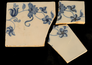
delft tile recovered from Graeme Park

            Hope Lodge is a beautiful example of early Georgian architecture, constructed between 1743 and 1748 by a wealthy Quaker entrepreneur.  Samuel Morris operated a mill nearby known as Mather Mill.  These properties also passed through several families before eventually being donated to the Commonwealth in 1957.  Hope Lodge  benefitted from preservation efforts in the 1920’s by the Degn family who cared for and restored the house and grounds. Archaeology conducted here revealed a property that had undergone many changes and unfortunately no intact wells or privies were located which would provide us with tangible evidence of the everyday lives of these occupants. 
            Montgomery County is rich in historical sites and our time here doesn’t permit us to cover them all, but we would be remiss in not addressing Valley Forge. Valley Forge served as the winter camp for General George Washington and the Continental Army during 1777-1778. Archaeology was conducted as early as 1921 at this site primarily focused on locating the hut encampments and recovering artifacts which would provide evidence of the daily lives of these soldiers.  Washington’s original orders for the design of this camp called for the construction of huts fourteen by sixteen feet along streets with officer’s huts to the rear. Archaeology revealed that these huts were significantly smaller (twelve feet square was large) and based on their irregular placement, they do not appear to have been laid out along streets. 
Excavations produced military artifacts including buttons, musket balls and ceramics used by this diverse group of soldiers. Archaeologists continue to examine these collections and those produced during current excavations  to better understand the hardships endured during this famous winter encampment. 
Uniform buttons recovered at 36Mg29 Weedon's Hut


            We hope you have enjoyed this journey through the archaeological heritage of Montgomery County and you will seek additional reading at the links provided above or through the publications listed in the bibliography.  Understanding and exploring our archaeological heritage is pivotal to our understanding of human behavior and our ability to change and adapt over time- just as the peoples of Montgomery County have done for thousands of years.


References

Custer, Jay F.
1996    Prehistoric Cultures of Eastern Pennsylvania. Anthropological Series No. 7,                                              Pennsylvania  Historical and Museum Commission, Harrisburg.

Kingsley, Robert G., Robertson, James A. and Roberts, Daniel G.
1990    The Archaeology of the Lower Schuylkill River Valley in Southeastern Pennsylvania. Prepared for the Philadelphia Electric Company by John Milner Associates, Inc.

Parrington, Michael
1980   Revolutionary War Archaeology at Valley Forge, Pennsylvania. North American Archaeologist, Vol. 1 (2) 1979-1980

Young, Michael L. and Donna Andrews
2003    Phase I/II Archaeological Investigations Heritage Golf Club Property, Limerick and Lower Pottsgrove Townships, Montgomery County, Pennsylvania. Unpublished Report, Section of Archaeology, The State Museum of Pennsylvania.


For more information, visit PAarchaeology.state.pa.us or the Hall of Anthropology and Archaeology at The State Museum of Pennsylvania .